La Palma volcano | news summary for Monday 6 December
Latest news and information on the Cumbre Vieja volcano, which began erupting on the Spanish Canary Island of La Palma on 19 September.
Show key events only
Headlines
- 14 earthquakes registered on Monday morning, strongest with a magnitude of 3.5 at a depth of 14km. Lava continues to flow west from the main Cumbre Vieja vent, mostly through lava tubes.
- Cumbre Vieja volcano has been erupting for over 11 weeks
- Early-December holiday weekend sees tourists flock to La Palma
- Just over 2,700 buildings destroyed on La Palma, according to Copernicus Earth observation programme
- "Favourable" conditions for operation of flights in and out of La Palma, per DSN
Useful information
- Expert in volcanology speaks to AS about the effects of lava reaching the sea
- The lowdown on the active volcanoes on the Canary Islands
- Where are most volcanoes located on Earth and how are they formed?
La Palma eruption: related articles
3-D(ish) fly-over
A neat fly-over of the map of the lava flows from the Cumbre Vieja eruption site and down to the Atlantic Ocean showing how they've grown over the past two weeks.
Info from Copernicus overlaid onto Spain's National Geographic Institute map. (Talking of the National Geographic Institute's maps, you can get very cool relief maps of the Canary Islands, as well as other parts of Spain from their online shop - will be interesting to see when they release the updated map with the new land from the lava flows on it)
Volcanic Nativity Scene
The volcanologists of the National Geographic Institute, who have been working day-in, day-out since the start of the eruption on the 19 September, have built a Nativity Scene entirely from lava and pyroclastic materials (cooled, we understand), in order to wish everyone a very merry Christmas.

Who owns the new bit of land in the sea?
The lava delta that has formed in the ocean belongs to the Spanish state, under the Law of the Coasts, which states that land or islands that are created due to "natural causes" in the sea automatically become property of the state.
Drone footage of Las Hoyas
Here’s some footage, both infrared and visual, taken from a drone flown by Spain's Military Emergencies Unit (Unidad Militar de Emergencias) of the lava in the Las Hoyas area, taken this morning. Much of the lava is flowing under a crust of cooled lava, hence it can be seen on the infrared, but to the naked eye there are only small sections where the glowing red lava can be seen.
Mapping La Palma lava flow
Copernicus is the EU's Earth observation programme, relying on satellite and in-situ data.
Cracks on the secondary cone
There are a number of cracks and fractures on the upper part of the secondary volcanic cone, however experts from PEVOLCA have determined these are unlikely to cause the cone to become destabilised or collapse at present, as they only affect the upper section of the structure.
However they may evolve over time and may lead to rock falls and structural collapse into the interior of the crater, with what is expected to be a localised effect.
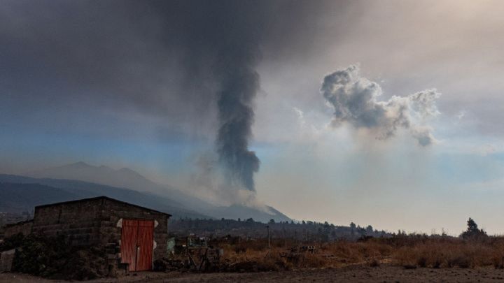
Air Quality
The air report for today from the Canary Islands government Safety and Emergencies department shows sulphur dioxide levels as good or very good, and PM10 particulate matter levels at good to average. Obviously your mileage may vary depending on how close you are to the eruption itself, and we would urge caution, and to check the latest advice from the authorities if you are on the island anywhere near the volcano. Of particular danger are emissions of carbon monoxide, an odourless gas that can cause death rapidly if inhaled.
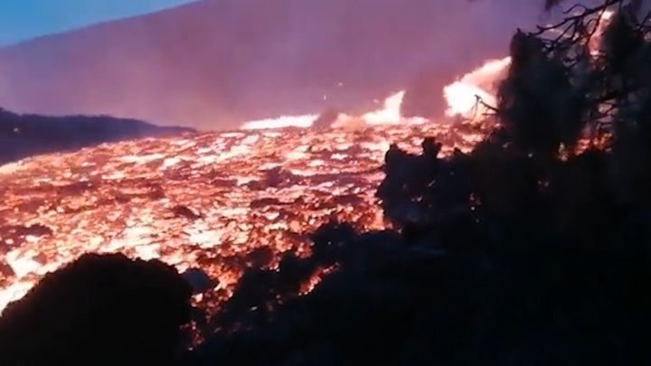
La Palma volcano eruption: drone flies low over rivers of lava
Televisión Canaria (RTVC) sent a drone over rivers of lava pouring out of the Cumbre Vieja eruption, offering spectacular views of the volcano's activity.
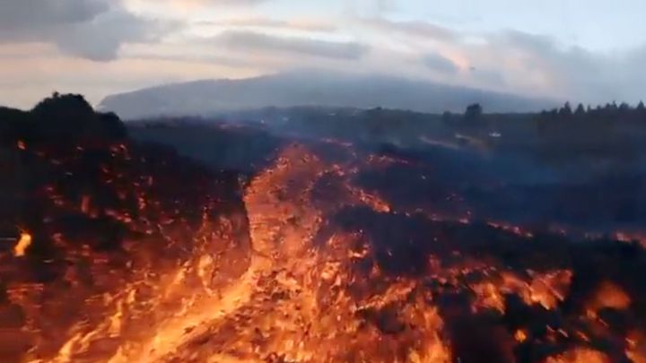
Lava flows on La Palma
Award-winning photographer Emilio Morenatti has shared a photograph of lava flowing behind a house on the island on La Palma.
Involcan - This photograph taken at 10 am on December 6 shows lava flowing down a cliff on La Palma.
How the volcanic eruption is affecting pine forests in La Palma
El País - Marta Martín is a forest engineer and tourist guide, specializing in routes that take in La Palma’s rich natural heritage. “I usually explain to groups that La Palma is a small continent, with a massive variety of landscapes,” she says. “We have arid land to the south, which is almost desert-like, and areas that resemble jungles, such as the laurel forests in the north.”
Tourist numbers rocket over December mini-holiday
The number of tourists visiting La Palma during the December 'puente'* have equalled those recorded at the height of summer last August. Officials say that hotel bookings in the east and north are up with 85% occupancy from the weekend to Wednesday. Binter, the Canary Islands' principal airline, has scheduled 32 extra flights between La Palma and Tenerife Norte and Gran Canaria between 5 and 9 December while Fred Olsen will be putting on two extra ferry services between Los Cristianos and Santa Cruz de La Palma during the mini-break.
*Spaniards describe a long weekend created by a public holiday as a 'puente', meaning bridge. Strictly to be a 'puente' the bank holiday has to fall such that by taking a day's vacation it creates a 'bridge' to the public holiday from a weekend, however in common usage 'puente' now just means any long weekend created by a public holiday, even when it falls on a Friday or a Monday.
The 6th and 8th of December are public holidays in Spain, meaning the 7th can be taken to bridge the gap between them. This year as the 6th is a Monday, it connects perfectly to create 5 days off, only needing one day's vacation, on the Tuesday.
Time lapse video of Cumbre Vieja clouds
We enjoy these time lapse videos from La Palma - this one, courtesy of the Canary Islands Meteorological Agency shows the clouds formed by Cumbre Vieja volcano over the course of Sunday afternoon-evening.
14 tremors registered on Monday morning in La Palma
The National Geographic Institute (IGN) has reported 14 tremors on La Palma during the early morning on Monday. The strongest, with a magnitude of 3.5 occurred at 8:23 hours local time in Fuencaliente - it was also the last earthquake reading this morning. Of the 14 tremors, 11 were in Fuencaliente, two in Mazo and one in El Paso.

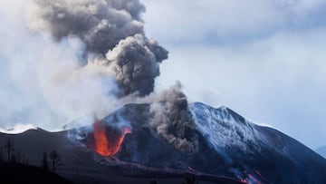
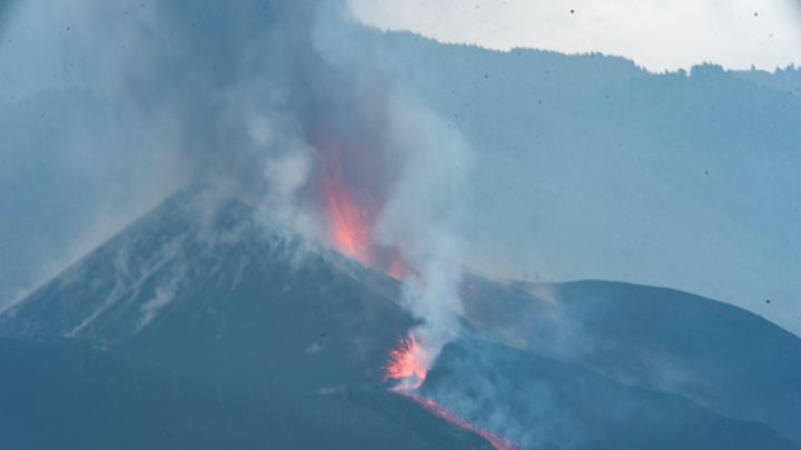
Main cone of La Palma volcano seen from the air
A photograph released by the Spanish Military Emergency Unit (UME) which shows a general view of the main cone of the Cumbre Vieja volcano on the Canary island of La Palma.
Wildlife slowly returning to areas affected by La Palma volcano
Slowly but surely, there are signs that wildlife is beginning to return to La Palma after almost 80 days constant volcanic activity. Leaves and flowers have started sprouting from plants and trees buried under lava and some species of wild bird have made the molten delta their temporary home.
La Palma residents can gain access to exclusion zone through app
The Canary Islands regional government has developed an app that will help residents who have been evacuated from their homes on La Palma to be granted access to the exclusion zone should they need to collect personal belongings. Only those who can prove that they are residents who have been displaced by the erruption will be able to download the form needed to be granted access - thanks to the app, the QR code can be downloaded onto a mobile phone. Previously, the form was only available as a printed sheet.
Where are most volcanoes located?
How are volcanoes formed? Where are they most commonly found?
AS USA's Greg Heilman answers these questions in this report.

Lava from new vent has destroyed "many buildings"
PEVOLCA confirmed that several vents on Cumbre Vieja reopened yesterday, from which several lava streams have been spurting out and moving at great velocity over terrain which previously had been untouched and creeping towards Las Hoyas.
The vent which opened up on the west side of Las Manchas cemetary has produced a new lava stream which is causing damage to an "extensive area of housing". PEVOLCA technical director Miguel Ángel Morcuende explained that vents have opened up in the lower parts of the volcano, the most concerning one 2 kilometres from the cone.
The new lava stream is advancing between Tazacorte and Los Llanos de Aridane, merging with stream No.9 and feeding the delta which has formed on the coast.
In total, 1,155 hectares have been affected and 2,771 buildings have been damaged or destroyed.
Infrared thermal images of La Palma volcano erruption
Another video courtesy of INVOLCAN, shot with a infrared thermal imaging camera to contrast yesterday's erruption filmed on a standard video camera. Clearly seen on the thermal images are the new emission points in the south side of the volcano and the absence of activity from the secondary cone.
New vents opening up on Cumbre Vieja
During the past few days several new vents have opened up on the east and west flanks of Cogote mountain - all of the which have been emitting streams of liquid lava. Those lava streams have been affecting residential zones in areas which have been evacuated, the National Security Department report.
The lava now covers approximately 1,155 hectares of land, 3,350 metre at its widest point while the deltas span 48.03 hectares.
Good morning and welcome to our live coverage of the eruption of the Cumbre Vieja volcano on the Canary Island of La Palma. Today marks exactly 11 weeks since the volcano began erupting on 19 September.
The lava flowing from the Cumbre Vieja now covers approximately 1,155 hectares of land on La Palma, in addition to forming close to 50 hectares of deltas off the coast of the island.
Nearly 3,000 buildings have now been destroyed by the lava stream, according to figures compiled by the EU's Copernicus Earth observation programme.
- Volcanic eruption La Palma
- Tenerife
- Pedro Sánchez
- Earthquakes
- Volcanic eruptions
- Provincia Santa Cruz de Tenerife
- Presidencia Gobierno
- Volcanes
- Spanish government
- Earthquake
- Canarias
- Natural disasters
- Natural spaces
- Disasters
- Government
- Accidents and crimes
- State administration
- Spain
- Environment
- Public administration
- Politics