6.4-magnitude earthquake hits Northern California: How are earthquakes measured?
Northern California was hit by a powerful earthquake on Tuesday resulting in injuries and two fatalities as well as knocking out power to tens of thousands.
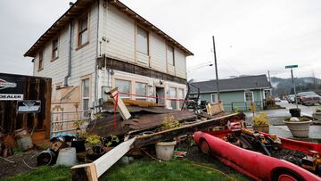

Residents in the area of Eureka in Northern California were quite literally shaken out of bed on Tuesday morning when powerful earthquake struck at 2:34 am PT. The 6.4-magnitude tremblor with its epicenter off the Cape Mendocino in the Pacific was followed by dozens of aftershocks, some up to 4.6 in magnitude.
The earthquake caused damage to buildings as well as roads and resulted in over ten injuries and two fatalities. Power and water have been knocked out to tens of thousands. The tremblor comes a year to the day of another earthquake off the Cape Mendocino in Humboldt County with a 6.2 magnitude.
Earthquake swarm continues to impact Eureka, California region as pressure builds on a critical tectonic plate intersection North of San Francisco. Here’s a video of the past 24 hours. > m1.0 #earthquake #video pic.twitter.com/OnTRV3UITv
— Scott Walters (@ScottWaltersCDN) December 20, 2022
So how do scientists measure earthquakes?
The United States Geological Survey (USGS) has a network of seismographs spread across the US and its territories which can detect when the earth shakes. They capture seismic waves as they travel through the earth. When at least three stations pick up on the primary wave and the secondary seismic wave, researchers can determine where the epicenter of the disturbance occurred.
The Richter scale
Most people have probably heard of the Richter scale referred to when talking about how powerful an earthquake is. While the system to compare quake sizes is still used to forecast future earthquakes and calculate earthquake hazards, it has been replaced due to its limited application and detecting abilities.
The 6.4 earthquake in northern California's Humboldt County is a reminder to always be prepared. Here's a refresher video on what to include in your emergency kit. pic.twitter.com/Lxnbtq2I8Q
— Los Angeles County (@CountyofLA) December 20, 2022
New way to measure earthquake magnitude
The Richter scale only picked up one type of seismic wave from an earthquake, detecting only those that occurred within about 370 miles of a seismometer. Since 1970 the Moment Magnitude Scale (MMS) is used as it can record all the different seismic waves from an earthquake that reach seismographs around the world.
Related stories


The MMS is able to measure the local scale, or Richter, the body wave and the surface wave. This gives it the ability to more accurately measure larger earthquakes and the rock movement along a fault line according to the California Earthquake Authority.
Earthquake magnitude classes
| Magnitude | Descritpion/Damage |
|---|---|
| 4.0 - 4.9 | Light, likely felt |
| 5.0 - 5.9 | Moderate, some minor damage may occur |
| 6.0 - 6.0 | Strong, damage likely |
| 7.0 - 7.9 | Major, widespread damage expected |
| 8.0 or higher | Great, significant damage |
| Source: | California Earthquake Authority |
Earthquake intensity also measured
The amount of destruction an earthquake causes and the on-the-ground sensation of what people feel is also measured. However, this measure of intensity can differ depending on the distance from the epicenter where the reading is taken. This results in multiple readings as opposed to just one for magnitude. The following Modified Mercalli (MM) Intensity Scale is used.
| Intensity | Shaking | Descritpion/Damage |
|---|---|---|
| I | Not felt | Felt by very few people, if at all. |
| II | Weak | Felt by a few people. |
| III | Weak | Felt by mainly by those indoors on upper floors. |
| IV | Light | Felt by few outdoors but many people indoors. |
| V | Moderate | Felt by nearly everyone, wakes people from their sleep. |
| VI | Strong | Felt by everyone many become frightened. Causes some slight damage. |
| VII | Very strong | Considerable damage to poorly built structures. Negligible to well-built structures. |
| VIII | Severe | Considerable damage to standard buildings, chimneys, factory stacks and walls fall. |
| IX | Violent | Buildings shifted off foundations, considerable damage to structures designed to withstand earthquake, sustanstial destruction. |
| X | Extreme | Some well-build wood structures destroyed, and most masonry structures destroyed. Rails bent. |