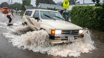
California storms, flooding and mudslides: the state’s wild weather explained
The extreme weather in California is nothing new but climate change and an wavy jet stream is exacerbating the “atmospheric river” phenomenon.

California has been battered in recent days and weeks by a series of “atmospheric rivers” that have brought the state much needed rain. But too much of a good thing can create problems especially when coupled with other factors such as the bomb cyclone intensifying the winds and wildfire scarred landscapes caused by the long-running drought which the Western United States have been dealing with.
Climate change is providing the perfect storm to exacerbate all of these conditions creating a whiplash of weather events. This year the weather is especially crazy due to a wavier than normal jet stream which is now carrying vast amounts of moisture from the Pacific Ocean and dumping it on the West Coast with California taking the brunt of it.
Atmospheric rivers bring vital rain but hazards as well
In the case of West Coast and Canada, the massive flow of water through the sky is called the “Pineapple Express” due to its origin in the tropical Pacific around Hawaii, a state associated with the sweet fruit. The atmospheric phenomenon, found in other parts of the world, is essential in the water cycle around the globe delivering the heaviest rains of the year to areas where they are present.
In honor of #TimelapseTuesday, here's an extended imagery loop showing the #AtmosphericRiver events that have been affecting the West Coast.
— NOAA Satellites (@NOAASatellites) January 10, 2023
This GeoColor imagery is from @NOAA's #GOESWest satellite, and spans from Jan. 6–10, 2023. pic.twitter.com/2F0unDB4Ew
With the atmosphere warming, more moisture can be held in the air. That means more arid summers as the land is scorched by extreme heatwaves and heavier downpours when the rains finally arrive in the wet months. According to research those events that make landfall, around 24 on average each winter on the US West Coast, are lasting longer, just over 5 days versus less than 4 days on average, and have stronger intensity.
Scientists at the University of California San Diego Scripps’ Center for Western Weather and Water Extremes rank atmospheric rivers depending on their duration and intensity much like hurricanes on a scale of 1 to 5. The current triple wave of events was predicted to be a Category 3, a “balance of beneficial and hazardous,” and increasing to a Category 4, “mostly hazardous, also beneficial.” The highest category is deemed to be “primarily hazardous.”
When combined with the current jet stream and bomb cyclone former chief scientist of the National Oceanic and Atmospheric Administration Ryan Maue described it as “a runaway Pacific freight train loaded with moisture” in an email to NPR. He said: “Climate change adds more fuel to the locomotive engine.”
The California storms, induced by so-called 'atmospheric rivers' and 'bomb cyclones,' have left at least 12 people dead and prompted evacuations of some 25,000 people https://t.co/XIg1gHzG6g pic.twitter.com/Vfd6rRcNVc
— Reuters (@Reuters) January 10, 2023
Heavy rains bring flooding and mudslides to California
Related stories
The Pineapple Express, also referred to as a “conveyor belt” of moisture, while it brings much needed rain, it can also create conditions that cause damage and destruction. Again, like hurricanes the stronger the atmospheric rivers, the more damage they produce. Researchers at Scripps found that these weather events “pose a $1 billion-a-year flood risk in the West.”
The torrential rains soak the ground but when areas are hit by back-to-back deluges the water-logged soil cannot hold any more water providing the conditions for flooding. It also provides the perfect conditions for mudslides, and landscapes denuded by wildfires have nothing to keep the ground from ceding nor stop the accumulating rainfall from rushing down the steep slopes, take everything in its path with it.


