China’s move on the ocean floor: Mapping the oceans
From oceanographic scientific projects to "ensuring maritime defense and security", China has spent years analyzing the seabed and shipping lanes using sensors.
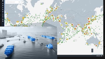
After the satellite images we saw the other day showing China conducting maneuvers with fishing vessels in various military-style formations, new mapping data now shows how the country is methodically charting the oceans through a vast undersea surveillance and cartography operation across the Pacific, Indian, and Arctic Oceans.
The goal? To gain the most detailed possible understanding of maritime conditions that, according to naval experts, would be critical in any future undersea conflict with the United States and its allies.
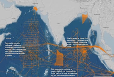
For example, the Dong Fang Hong 3, a research vessel operated by Ocean University of China, spent 2024 and 2025 sailing through waters near Taiwan and the U.S. stronghold of Guam, as well as strategic areas of the Indian Ocean, according to ship-tracking data reviewed by Reuters. Naval warfare experts and U.S. Navy officers say the type of deep-water data collected by the Dong Fang Hong 3 through seafloor mapping and sensor deployment gives China the underwater environmental picture it needs to operate its submarines more effectively and detect those of its adversaries.
In October 2024, the vessel inspected a set of powerful Chinese ocean sensors capable of detecting underwater objects near Japan, according to Ocean University of China, and it returned to the same area in May of last year. In March 2025, it traveled through the waters between Sri Lanka and Indonesia, covering the approaches to the Strait of Malacca, a strategic chokepoint vital to global maritime trade.
All of this further reinforces the idea that China is using networked marine sensors and building a permanent technological infrastructure beneath the sea. The Taipei Times has reported that Chinese oceanographic vessels are mapping the seafloor, with multiple parallel passes detected near Taiwan’s east coast, a pattern characteristic of military hydrographic surveys.
The data collected could be used for submarine navigation, the detection and disabling of undersea cables, or preparation for laying naval mines. China relies primarily on civilian research ships, which helps reduce international scrutiny and makes tracking these operations more difficult.
Five years of civilian research, and military implications
Reuters reviewed records from Chinese government agencies and universities, including journal articles and scientific studies, and analyzed more than five years of movements from 42 research vessels active in the Pacific, Indian, or Arctic Oceans, using a ship-tracking platform developed by New Zealand company Starboard Maritime Intelligence.
While the research serves civilian purposes, including studies of fishing grounds and areas where China holds mineral exploration contracts, it also has a military dimension, according to nine naval warfare experts who reviewed Reuters’ findings. “The scale of what they’re doing is about more than just resources. If you look at the sheer extent of it, it’s very clear that they intend to have an expeditionary blue-water naval capability that also is built around submarine operations,” said Jennifer Parker, an adjunct professor of defense and security at the University of Western Australia and a former Australian antisubmarine warfare officer.
Peter Scott, former head of Australia’s submarine force, said that “any military submariner worth his salt will put a great deal of effort into understanding the environment he’s operating in.” The reporting found that ship-tracking data shows China’s efforts to survey the seabed are focused in part on militarily important waters around the Philippines, near Guam and Hawaii, and close to U.S. military facilities on Wake Atoll in the North Pacific.
“It is frankly astonishing to see the enormous scale of Chinese marine scientific research,” said Ryan Martinson, an associate professor specializing in Chinese maritime strategy at the U.S. Naval War College.
“Deeply concerning”
“For decades, the U.S. Navy could assume an asymmetric advantage in its knowledge of the ocean battlespace. [China’s efforts] threaten to erode that advantage. It is obviously deeply concerning.”
The vessels involved belong to Chinese state entities such as the Ministry of Natural Resources or to state-affiliated research institutions such as Ocean University of China, whose president publicly celebrated in 2021 the school’s “close ties” to the Chinese navy and its commitment to “the construction of a maritime power and national defense.”
One of the most heavily surveyed areas stretches from the Japanese islands in the north, past Taiwan, and down to Borneo in the south, forming a natural barrier between China’s coastal waters and the Pacific.
Chinese scientists say these sensors are used to monitor climate shifts and changing ocean conditions. But in 2017, officials in Shandong province stated that the “transparent ocean” project was intended to “ensure maritime defense and security” and explicitly compared it to a U.S. military effort to build a network of ocean sensors.
According to Collin Koh, a senior fellow for maritime security at Singapore’s RSIS Institute of Defence and Strategic Studies, China now has “a reasonably good picture of the maritime domain they hope to operate in, either in peacetime or in war,” and there may be no better time than now to put that reality on the map.
Related stories
Get closer to the game! Whether you like your soccer of the European variety or that on this side of the pond, our AS USA app has it all. Dive into live coverage, expert insights, breaking news, exclusive videos, and more. Plus, stay updated on NFL, NBA and all other big sports stories as well as the latest in current affairs and entertainment. Download now for all-access coverage, right at your fingertips – anytime, anywhere.
And there’s more: check out our TikTok and Instagram reels for bite-sized visual takes on all the biggest soccer news and insights.
Complete your personal details to comment