How do hurricanes form and why is their east side worse?
No respite for Florida, with another hurricane developing in the Gulf of Mexico. How are hurricanes formed and the dangers of a storm’s east side.


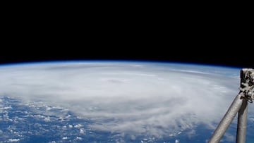
Hurricane Helene and the storms it brought to the southeast have claimed the lives of hundreds, with hundreds of people still missing. Florida will have little time to recover before another storm hits the peninsula. Tropical Storm Milton, which has developed in the Gulf of Mexico, is expected to continue gaining strength and make landfall around Tampa on Wednesday as a Category 3 hurricane.
Another hurricane is building in the Gulf of Mexico
Earlier this year, the National Oceanic and Atmospheric Administration (NOAA) forecasted an “above-average” hurricane season. NOAA estimates that before November 30, the agency will track between 17 and 25 named storms. Milton is the thirteenth named storm of the season, and there are still two months left before hurricane season comes to a close.
4PM CDT Oct 5: Tropical Storm Milton is forecast to strengthen quickly and bring the risk of life-threatening impacts to portions of the west coast of Florida Tuesday or Wednesday. Make sure to check back for updates through the weekend and into next week at… pic.twitter.com/ODXkMcuLAz
— National Hurricane Center (@NHC_Atlantic) October 5, 2024
The warm sea heats the air, and as water evaporates, it rises and cools, condensing into large water droplets. This forms large cumulonimbus clouds, which release more heat into the air, cause more water to evaporate, and continue the cycle, building the cloud columns higher and wider.
As the column grows taller, it becomes precarious. As the air pressure increases, strong winds surge outward from the central point. This is called a tropical depression, and at this point, the column of clouds begins to move in a circular motion, spinning faster and faster.
Once the wind speeds reach 39mph, the tropical depression becomes a tropical storm, a phenomenon identified in the Atlantic weeks ago. As the process continues, the winds blow stronger and begin to push the spinning column of cloud either east or west.
The winds gain momentum as the column moves, and once the wind speed reaches 74mph, the storm officially becomes a hurricane. By this point, the system is at least 50,000 feet high and 125 miles wide, with the eye of the storm spanning up to 30 miles alone.
Is the ‘right’ side of the hurricane more dangerous?
You may have heard meteorologists refer to the ‘dirty side’ of a hurricane, or suggest that the eastern side is more deadly. This is a real phenomenon and one that has to do with steering currents driven by atmospheric air flow.
Related stories
In the northern hemisphere the winds that cause the system to spin are usually strongest in the upper-right quadrant, when seen from an aerial view. This means that the energized ‘right’ side of the hurricane can create higher wind speeds, larger waves and a more pronounced storm surge.
This effect is even more dangerous if the right side of a hurricane aligns with a body of water, such as a bay or a river. This is very difficult to predict precisely, so officials normally advise residents stay away from all bodies of water when issuing a hurricane warning.

Complete your personal details to comment