Hurricane Beryl: Could it hit the US? Projected and real time path
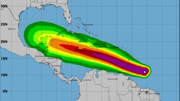
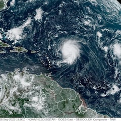
Hurricane Beryl, the earliest Cat 4, is currently plowing into the Windward Islands of the Caribbean but as it continues westward models differ on its path.

The 2024 Atlantic hurricane season is not even a month old, and it has already produced two named storms. The National Oceanic and Atmospheric Administration (NOAA) is predicting that this year will be above normal with as many as 25 named storms. Four to seven of them could be major category 3, 4 or 5 hurricanes.
Currently, the second, Beryl, has intensified to a Category 4 as it approaches the Windward Islands of the Caribbean. St Vincent, the Grenadines and Grenada are at highest risk of receiving the brunt of Beryl’s 130-plus mph winds beginning early Monday morning.
Meteorologists are predicting that the “extremely dangerous” hurricane will continue along a relatively straight path westward toward the Yucatan Peninsula arriving there Friday morning. From that point though, the Euro forecast and the NOAA Global Forecast System (GFS) prediction models differ on where Beryl will go next.
Hurricane Beryl: Could it hit the US? Projected and real time path
The National Hurricane Center warns that “there is large forecast uncertainty at days 4 to 5″ and that people consulting information of Beryl “should not focus on the specific details of the track or intensity.”
Pretty interesting to see the global models work through intensification and eventual paths for now major hurricane #Beryl-
— Eric Burris (@EricBurrisWESH) June 30, 2024
Down the line, high pressure is protecting us seemingly, but where will a weakness in the high develop? That's where Beryl could swing north a bit. pic.twitter.com/TkSJf288Zp
The GFS forecast is predicting that Beryl will weaken as it moves west and take a slightly more northerly route across the Caribbean putting its track directly over Jamaica and the Cayman Islands. After crossing the tip of the Yucatan Peninsula it would turn slightly north according to the model and gain strength as it heads for the Texas Gulf Coast making landfall between Corpus Christi and Houston.
Related stories
Currently, according to the Euro forecast, Beryl will slam into the Yucatan Peninsula in the border region of Mexico and Belize with very strong winds. After weakening as it goes over land it will regain strength and continue its march toward the general area where its predecessor, Tropical Storm Alberto, made landfall on 20 June.
That storm had the widest wind field in 20 years delivering tropical storm force winds well up the Gulf Coast. Many costal communities in Texas experienced significant flooding due to those winds creating major storm surges aided by full moon high tides, along with the heavy downpours.


Complete your personal details to comment