Hurricane Francine tracker: Affected areas today, Sept. 11
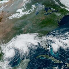
After developing into a Category 1 hurricane over Tuesday, Francine is set to hit the US coast at Louisiana on Wednesday evening.
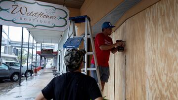

Francine, now a Category 1 hurricane, is rapidly approaching the Louisiana coast, prompting widespread preparations and evacuations across the Gulf region. The storm is located approximately 360 miles southwest of Morgan City, Louisiana, and is moving northeast at about 10 mph
Itis expected to make landfall around 7 p.m. on Wednesday, 11 September.
Affected areas today
Louisiana is bracing for the brunt of Hurricane Francine:
A Hurricane Warning is in effect from Cameron to Grand Isle, including Baton Rouge. Mandatory evacuations have been ordered in multiple parishes, particularly in low-lying areas.
Storm surge of five to ten feet is expected from Rockefeller Wildlife Refuge to Port Fourchon, coupled with rainfall of four to eight inches, with local amounts up to 12 inches, across eastern Louisiana.
Related stories
While Texas is not expected to take a direct hit, coastal areas are experiencing impacts. Tropical Storm Warnings are in effect for southeast Texas, including Galveston Island and Bolivar Peninsula. Smaller but no insignificant levels of rainfall and storm surge will affect southern Texas.
A Tropical Storm Warning extends to the Alabama/Florida border. Storm surge warnings are in effect from the Sabine Pass to the Mississippi/Alabama border. For all, significant rainfall and potential flash flooding are expected.
Complete your personal details to comment