Lost to time: Nearly 5,000-year-old fort emerges from the forest
Once thought lost forever, the ancient stronghold has been mapped in detail thanks to breakthrough laser-scanning technology.
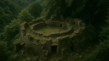

An ancient fortress dating back almost 5,000 years has been rediscovered in Romania after being hidden for centuries beneath dense forest vegetation.
The project, led by Geocad Services, Geo Edu Lab, and the National Institute for Research and Development for Earth Physics, used drones equipped with LiDAR technology to reveal the forgotten settlement.
What is LiDAR?
According to the National Ocean Service, LiDAR (Light Detection and Ranging) “uses light in the form of a pulsed laser to measure ranges (variable distances) to the Earth. These light pulses, combined with other data recorded by the airborne system, generate precise, three-dimensional information about the shape of the Earth and its surface characteristics.”
The technology has many uses, from surveying and mapping to virtual and augmented reality, and infrastructure monitoring. Crucially, it can also uncover hidden structures beneath vegetation or soil, as was the case in this groundbreaking study.
Technology cuts through dense forest vegetation
“Thanks to current technology and using LiDAR scans I was able to obtain a faithful image of an almost 5,000-year-old fortification,” said Vasile Diaconu, an archaeologist involved in the research. “On this occasion, we observed details that we could not observe in the field precisely because of the vegetation.”
Archaeologists believe the fortress dates back to the transition from the Neolithic period (c. 10,000 BCE to c. 2,000 BCE) to the Bronze Age (c. 3200–900 BCE).
“LiDAR scans showed that most of the fortified sites were located in high areas, which had good visibility and were reinforced by ditches and even earthen mounds in order to increase their defensive capacity,” Diaconu explained. “Field measurements indicated that some of these ditches had impressive dimensions with lengths of several hundred meters, which required considerable human effort in the construction.”
Related stories
Get your game on! Whether you’re into NFL touchdowns, NBA buzzer-beaters, world-class soccer goals, or MLB home runs, our app has it all.
Dive into live coverage, expert insights, breaking news, exclusive videos, and more – plus, stay updated on the latest in current affairs and entertainment. Download now for all-access coverage, right at your fingertips – anytime, anywhere.
Complete your personal details to comment