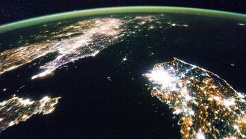
This is what the world's most illuminated cities look like from outer space
Black Marble is an interactive map created by NASA and Google in which you can see the most illuminated cities in the world from outer space.

Cities are getting bigger and more energy-intensive every day. This becomes more apparent at night, when bright lights serve as a testament to the energy being consumed by people.
Excessive artificial light produced by human activities brightens the night sky and disrupts natural darkness, but what does it look like from space?
Thanks to a tool called Black Marble, it’s possible to check out this view in real time.
READ ALSO: La Niña could worsen drought conditions in winter
What is the NASA-initiated project called Black Marble?
Use Black Marble, Google’s interactive map
Black Marble is a project created by NASA, Google and other corporations in 2017 with the aim of “providing a new source of information to improve understanding of the interaction between human systems and the environment.”
It also serves to analyze light pollution and detect activities such as illegal fishing and forest fires.

This is what the world’s most illuminated cities look like from outer space
In the following video shared by NASA you can see exactly how the tool works.
Black Marble provides detailed imagery of Earth at night, using satellite data to map and visualize artificial and natural light sources across the planet.
The term “Black Marble” is a counterpart to NASA’s famous Blue Marble images, which show Earth during the daytime.
READ ALSO: Warning for ‘devil wind’ in California
The program allows scientists to observe how light is distributed across the planet, providing insights into human activity, urbanization, and economic development.
Related stories
The images can detect human-made lights from cities, streetlights, and infrastructure as well as natural light sources such as wildfires, volcanic eruptions, and moonlight reflected off Earth’s surface.
During disasters like hurricanes or earthquakes, Black Marble data can show how power outages affect urban areas, providing critical information for response efforts and helping governments and aid organizations assess which areas need the most assistance.

