Tropical Storm Francine: When will it hit the US? Will it become a hurricane?
The storm will make landfall as a hurricane on Wednesday with safety measures and evacuations underway.


People living near the Gulf of Mexico should be prepared for a hurricane to hit their shores come Wednesday.
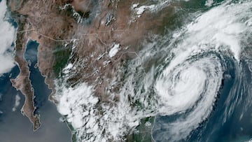
Francine formed from a cluster of thunderstorms in the Gulf, with current sustained winds of approximately 50 mph. The storm is located about 480 miles southwest of Cameron, Louisiana, and is moving in a northeasterly direction.
Meteorologists at the National Hurricane Center anticipate that Francine will gain strength as it traverses the exceptionally warm Gulf waters, where sea surface temperatures exceed 86°F.
“Francine is anticipated to be just offshore of the coasts of northeastern Mexico and southern Texas through today,” the center said Tuesday, “and make landfall in Louisiana on Wednesday. Francine will likely become a hurricane today, with significant strengthening expected before it reaches the coast.”
Projected landfall and intensity
As it approaches the coastline, the storm is expected to reach Category 1 hurricane intensity, with sustained winds potentially escalating to 85 mph. Some models suggest it could peak as a Category 2 hurricane, with wind speeds of up to 100 mph.
Potential impacts on the Gulf coast
Related stories
Coastal areas of Louisiana and upper Texas are at risk of experiencing a number of problems. Life-threatening storm surge, with predictions of up to ten feet in low-lying regions, will be accompanied by four to twelve inches of heavy rainfall.
A hurricane watch has been issued for the Louisiana coastline and the Coast Guard has implemented Port Condition Whiskey for major Texas ports.


Complete your personal details to comment