Post-Tropical Cyclone Helene news summary
Helene battered the Southeast, killing dozens of people in multiple states. The storm’s remnants will continue to bring rain and strong winds to the East.

Show key events only
Post-Tropical Cyclone Helene: Live Updates
Helene live tracker
Helene made landfall along the Florida coastline as a category 4 hurricane, bringing perilous conditions to the area. It then proceeded to wreak havoc on South Carolina, Georgia, Florida, North Carolina and Virginia.
The system has weakened but its remnants will continue to bring rain and gusty winds over hundreds of miles of Eastern U.S.
Watch the live tracker to monitor the weather system.
Hurricane Helene has left at least dozens dead in its wake. Here are past storms that have also caused a great number of fatalities in the United States.

Hurricane Helene has caused devastation and the loss of over 40 lives in recent days, and now experts are monitoring two other weather systems.
Find out if Hurricane Isaac and Tropical Storm Joyce pose a threat to the United States.
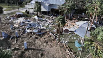
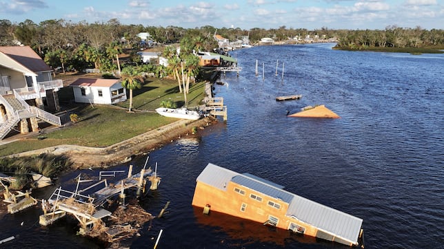
Property damage caused by Helene to run into billions
The winds and water brought by Helene destroyed homes and property, as well as infrastructure. This includes dams, roads, and historic bridges.
Moody’s analytics places total property damage to range from $15 billion to $26 billion.
Health emergency declared in Georgia
Department of Health and Human Services Secretary Xavier Becerra has declared a public health emergency for the state of Georgia to address the health impact of hurricane Helene.
Additional emergency personnel and resources will be deployed in the region to augment state and local response efforts.
The HHS had earlier declared an emergency for Florida.
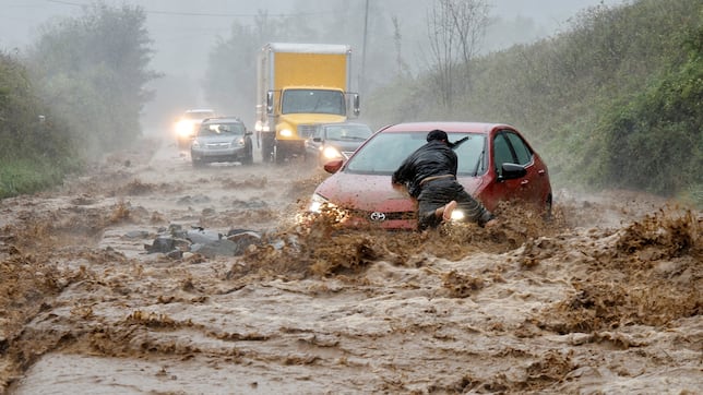
Floodwaters leave residents stranded on roofs
Helene's path of destruction was particularly deadly not only because of the winds it brought but the amount of rainfall it dumped.
The sheer volume of water caused massive flooding, sweeping cars away and leaving homes submerged.
Remnants of Helene continue to pose danger
The National Hurricane Center warns of continued danger from the remnants of Helene. The weather system is causing catastrophic flooding in the Southern Appalachians, with rainfall totals expected to reach six to 12 inches in some areas.
This could lead to life-threatening conditions, and residents are advised to avoid flooded areas and stay updated on emergency alerts.
The death toll from Hurricane Helene has tragically risen to 45 as the storm wreaks havoc across the southeastern United States.
In addition to this devastating loss of life, more than 3.2 million people are currently experiencing power outages across several states due to the severe winds and torrential rains that have battered the region.
We take a look at the worst hits areas and what's expected in the coming hours.
Cell site, cable and wireline outage and status in affected areas
The Federal Communications Commission gave the latest update on outages in the disaster area. Cable and wireline companies reported 7,278 subscribers out of service in affected areas.
This includes the loss of telephone, television, and/or Internet services, while 0.2% of the cell sites are currently out of service - Hillsborough, FL the worst hit with nine cell sites down.
Helene destroys much of Horseshoe Beach
As journalist and storm chaser Jordan Hall shares, these are tough scenes to watch.
The storm surge has left Horseshoe Beach in Florida destroyed with almost every house appearing to have sustained damage.
Rescue team saves man and dog
With so many people caught up in the impact of Hurricane Helene, the U.S. Coast Guard has been kept busy, always on the look out to help.
Here they share a video of their rescue of a man and his dog after their sailboat was disabled. Impressive efforts and some positive news.
Helene kills dozens, knocks out power: Live updates
Hello and welcome to AS USA's live blog covering Helene. The storm made landfall in Florida as a category 4 hurricane on Thursday bringing life-threatening conditions to the area.
It weakened as it moved inland, but continued to wreak destruction, leaving dozens dead and many others stranded in floodwaters. Helen also left millions without power.
Complete your personal details to comment