Tropical Storm Helene to hit U.S., these are the counties most at risk
Tropical Storm Helene is expected to intensify into a hurricane, grow in size, and make landfall in the U.S. on Thursday. Florida is most at risk.


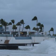
Tropical Storm Helene is gaining strength and is forecast to intensify into a hurricane and grow in size as it moves across the Gulf of Mexico. It is expected to make landfall on Florida’s coast on Thursday.
The National Hurricane Center says damaging hurricane-force winds can be expected along portions of the Florida Big Bend coast.
The agency urges residents along the Florida Panhandle and Big Bend region to complete their preparations to protect life and property by early Thursday, when dangerous weather conditions are expected to begin.
Keep yourself posted with our updates: Tropical Storm Helene approaches US: live updates
Emergency evacuations are underway in Florida as Tropical Storm Helene is expected to grow into a Category 3 hurricane. Al Roker tracks the latest forecast. pic.twitter.com/TE3Laq8PLL
— TODAY (@TODAYshow) September 25, 2024
Tropical Storm Helene to hit U.S., these are the counties most at risk
Helene is a large storm and as it becomes even bigger, its impact will be more widespread, potentially extending hundreds of miles from its center. Its effects include storm surge, flooding, and powerful winds.
The storm is also expected to gather speed as it crosses the coast, which could result in “farther inland penetration of strong winds over the southeastern United States after landfall,” according to the hurricane center.
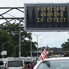
As part of preparations for the impact of Helene, Florida Gov. Ron DeSantis has declared a state of emergency in 61 of the state’s 67 counties, including the whole Florida Panhandle.
Here are the counties under a state of emergency.
- Alachua
- Baker
- Bay
- Bradford
- Brevard
- Calhoun
- Charlotte
- Citrus
- Clay
- Collier
- Columbia
- DeSoto
- Dixie
- Duval
- Escambia
- Flagler
- Franklin
- Gadsden
- Gilchrist
- Glades
- Gulf
- Hamilton
- Hardee
- Hendry
- Hernando
- Highlands
- Hillsborough
- Holmes
- Jackson
- Jefferson
- Lafayette
- Lake
- Lee
- Leon
- Levy
- Liberty
- Madison
- Manatee
- Marion
- Monroe
- Nassau
- Okaloosa
- Okeechobee
- Orange
- Osceola
- Pasco
- Pinellas
- Polk
- Putnam
- Santa Rosa
- Sarasota
- Seminole
- St. Johns
- Sumter
- Suwannee
- Taylor
- Union
- Volusia
- Wakulla
- Walton
- Washington
READ ALSO: What to do if your flight is canceled or delayed by Hurricane Helene
Meanwhile, here are the areas under watches or warnings as issued by weather officials.
Hurricane warning
- Anclote River to Mexico Beach, Florida
According to the National Weather Service, this warning means hurricane conditions (sustained winds of 74 mph or stronger) are expected somewhere within the specified area. A warning is issued 36 hours before the anticipated onset of violent winds to give residents ample time to prepare for dangerous conditions.
Hurricane watch
A watch means hurricane conditions (sustained winds of 74 mph or stronger) are possible within the specified area. A hurricane watch is issued 48 hours before the anticipated onset of tropical-storm-force winds.
Storm surge warning
- Indian Pass southward to Flamingo
- Tampa Bay
- Charlotte Harbor
A storm surge warning indicates the danger of life-threatening floods from rising water moving inland from the shoreline within the warning area, generally within 36 hours. This may be issued earlier when other conditions such as the onset of strong winds could limit the time available to take protective actions for surge, such as evacuations. The warning may also be issued for locations not expected to receive life-threatening inundation, but which could potentially be isolated by flooding in neighboring areas.
Tropical storm warning
- Dry Tortugas
- All of the Florida Keys
- The Florida west coast from Flamingo to Anclote River, including Tampa Bay
- West of Mexico Beach to the Walton/Bay County Line
- The Florida east coast from Flamingo northward to the mouth of the St. Mary’s
- River
- Lake Okeechobee
Related stories
A tropical storm warning means sustained winds of 39 to 73 mph or higher are expected in 36 hours or less. These winds may be accompanied by storm surge, coastal flooding, and/or river flooding.
Tropical storm watch
- The Georgia and South Carolina coast north of the mouth of the St. Mary’s River to the South Santee River
A tropical storm watch indicates a tropical cyclone containing winds of 39 to 73 mph or higher poses a possible threat, generally within 48 hours. These winds may be accompanied by storm surge, coastal flooding, and/or river flooding.
Complete your personal details to comment