What is the path of Hurricane Otis? Acapulco weather tracker
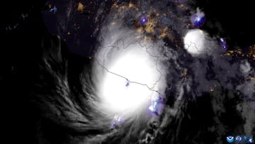
Hurricane Otis, one of the most rapidly intensifying on record, slammed into the coast of Mexico near Acapulco as a Category 5 storm with winds of 165 mph.

The first Category 5 Hurricane on record to ever make landfall in Mexico struck around 1:25 am local time Wednesday near Acapulco. What started as a tropical storm on Monday in the Pacific Ocean rapidly intensified to a Category 5 hurricane in less than 12 hours on Tuesday, the fastest strengthening on record in the northeast Pacific.
This created what the National Weather Service called a “nightmare scenario” with little time for residents of the 1-million-plus metropolis to prepare for the monster storm. Hurricane Otis was packing sustained winds of 165 miles per hour when it slammed into the coast just south of the resort city.
What is the path of Hurricane Otis? Acapulco weather tracker
Acapulco has suffered power outages, as well as throughout Guerrero, and extensive building damage. The city, which is located at the foot of steep mountains, has also reported flooding from the torrential rains, up to 20 inches is expected in parts of Guerrero and Oaxaca states, brought by the storm.
President Andres Manuel Lopez Obrador said that the Defense Ministry had enacted a disaster plan prior to the arrival of Hurricane Otis.
The explosive intensification of #Otis from Tropical Storm to Category 5 Hurricane in only a few hours, followed by a devastating landfall near #Acapulco, Mexico. pic.twitter.com/fA3xtRYpGK
— Zoom Earth (@zoom_earth) October 25, 2023
As of 10 am CDT the tempest was still a Category 1 storm with winds of 80 mph moving north northwest at 10 mph roughly 100 miles north northwest of Acapulco. It’s expected to continue downgrading as it moves inland but the wind and rain associated with the tropical weather system still present a danger.
Why did Hurricane Otis intensify so rapidly?
Related stories
Since 1980, the number of “rapid intensification” events has tripled within 240 miles of the coast according to a research paper in Nature. Rapid intensification is when a hurricane’s wind speeds accelerate by 35 mph or more in less than 24 hours. Predicting rapid intensification is difficult though, mainly because there are so many conditions that must align for it to happen.
However, experts are forecasting that it is becoming the norm as ocean water temperatures get warmer providing the necessary ingredients for hurricane formation. The increased evaporation releases ever more energy to feed the tempests. Additionally, the greater amount of humidity helps strengthen the storm systems. If there is little wind shear at higher altitudes the cyclones can maintain and augment their power.
Just to emphasize how poorly hurricane & global models performed for Hurricane Otis... here's the intensity forecasts initialized 24 hours ago, with the dotted black line showing verification: pic.twitter.com/DN5pf7lcOS
— Tomer Burg (@burgwx) October 25, 2023


