When will Hurricane Ian hit South Carolina and how long will it last?
The east coast of the United States is braced for the tropical storm to come ashore once again, with extreme weather warnings in place for four states.


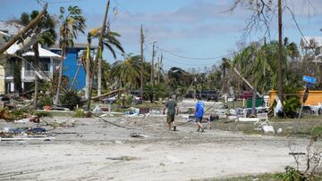
On Thursday afternoon the National Hurricane Center (NHC) released a statement suggesting that a drop in wind speeds meant that Hurricane Ian was officially downgraded to a tropical storm, but warned that wind speeds are likely to pick up again in the near future.
“Ian is expected to become a hurricane again this evening and make landfall as a hurricane on Friday,” the NHC said on Thursday.
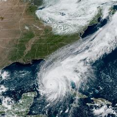
The storm is now leaving Florida but experts are warning that, as it travels north over the Atlantic, it will likely pick up speed and be reclassified as a hurricane. The warm Atlantic waters which spawned the tropical storm initially are expected to add fresh impetus and a hurricane warning has been issued for coastal areas of South Carolina, near Charleston.
Related news
Hurricane Ian expected to make landfall in South Carolina
There are currently active weather alerts in place across four states, stretching from Florida in the south through Georgia, and up to both South and North Carolina. The whole coast of South Carolina has been issued a hurricane warning, while much of North Carolina, inland South Carolina, eastern Georgia and Florida’s east coast are currently under a tropical storm warning.
It is South Carolina that is expected to bear the brunt of the next landfall and current forecasts project that the hurricane could hit Charleston in the late morning or early afternoon Friday.
At 11am EDT the center of #Ian has emerged into the western Atlantic & is expected to become a hurricane again this evening & make landfall as a hurricane on Friday. Hurricane Warning issued for the entire coast of South Carolina. https://t.co/meemB5uHAR pic.twitter.com/HXwtwiwBDR
— National Weather Service (@NWS) September 29, 2022
Charleston could be the epicentre of the storm in the next 24 hours, with meteorologists warning of 7-foot storm surges and a severe risk of flooding. By the weekend up to 10 inches of rain could have fallen which, when combined with the tidal disruption, makes flooding inevitable.
How long will Hurricane Ian last?
The hurricane relies on the energy provided by the warm Atlantic water to maintain high wind speeds and once it begins to move inland it will begin to slow. Experts have observed this in the past 24 hours, as Hurricane Ian slowed to a tropical storm after making landfall in Florida and then speeding up over the Atlantic.
The route that the hurricane takes will be vitally important. Meteorologists currently anticipate that the system will continue to move in a north-western direction, with heavy rains expected in Philadelphia and New York City by Saturday morning.
There is evidence that the hurricane is beginning to slow, with South Carolina not expected to experience wind speeds as high as those in Florida earlier this week, but it could still cause severe damage.
The journey of #Ian from its inception. It'll likely become a hurricane again before hitting South Carolina on Friday. pic.twitter.com/fuHVQJL4Vj
— Tyler Eliasen FOX 13 (@FOX13Tyler) September 29, 2022
Related stories
South Carolina Emergency Management Director Kim Stenson said: “While we will not see the full force of Hurricane Ian the way Florida did, we could see high winds, rain, flash flooding and even tornadoes.”
Even if the hurricane in downgraded to a storm and begins to dissipate in the coming days, the longer-term consequences of widespread flooding, infrastructure damage and the destruction of personal property could take years to be rectified.

