Where will Hurricane Milton pass? Map of affected areas, states and cities
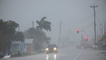
Florida is preparing for the impact of Hurricane Milton, expected to make landfall in the early hours of Thursday, Oct. 10. See the map of affected areas.
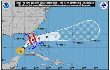
Milton is approaching Florida’s west coast with maximum sustained winds of 150 miles per hour, teetering between Category 4 and 5 on the Saffir-Simpson Hurricane Scale. The hurricane formed on Saturday, Oct. 5 in the Gulf of Mexico, and in just 20 hours it intensified into a Category 5 hurricane.
According to the National Hurricane Center, Milton is expected to make landfall on the west coast of Florida as a major hurricane between 2 a.m. and 6 a.m. local time on Thursday, Oct. 10. Destructive storm surge with inundation of 10 feet or more is expected along a portion of the west-central coast of the Florida peninsula. The time to evacuate ends Wednesday afternoon.
READ ALSO: Hurricane Milton shelters in Florida
Life-threatening hurricane-force winds will extend inland, while heavy rainfall across the Florida peninsula carries the risk of catastrophic and life-threatening flash and urban flooding, along with moderate to major river flooding.
200 PM EDT Wed Oct 09 2024
— National Hurricane Center (@NWSNHC) October 9, 2024
...#MILTON GROWING IN SIZE AS IT MOVES CLOSER TO THE WEST COAST OF #FLORIDA...
...LIFE-THREATENING STORM SURGE, DAMAGING WINDS, AND FLOODING RAINS EXPECTED ACROSS PORTIONS OF CENTRAL AND SOUTHWESTERN FLORIDA
For more information: https://t.co/0qJ2lutNUL pic.twitter.com/BL40qkFDn6
READ ALSO: Cities in Florida are facing fuel shortages as Hurricane Milton moves in
Where will Hurricane Milton pass? Map of affected areas, states and cities
At the moment, the only state in Milton's direct path is Florida, which was hit by Category 4 Hurricane Helene just two weeks ago. Here's the forecast cone map:
READ ALSO: What a Category 6 hurricane would look like
Related stories


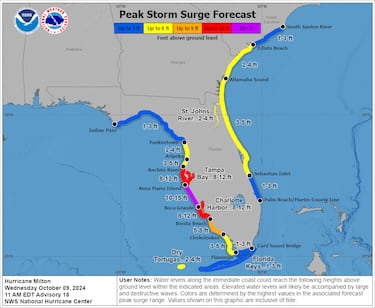
The hardest hit area will be Tampa Bay, where Milton is expected to make landfall, causing the worst storm in the region in 100 years. Other areas such as Charlotte, Boca Grande, Anna Maria Island, Anclote River and Chokoloskee are also expected to be severely affected. Here is the expected water level for each region in Florida.
To keep yourself updated on the latest storm warnings and advisories, check the websites of your local National Weather Service office, the National Hurricane Center, and your local emergency management/government office.
Complete your personal details to comment