


CLIMATE
Will the 2024 hurricane season be prolific? This is what the experts say
Hurricane season is off to a historic start, with experts raising concerns about what is to come not only this year but in those to come.

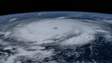
Hurricane season begins on June 1 each year, and this year, it is off to a historic start. Hurricane Beryl has left a path of devastation across the Caribbean, with the Cayman Islands awaiting the storm’s arrival this evening.
This image captured at the International Space Station might help you understand the size of Hurricane Beryl.
NOAA’s warning about the 2024 Hurricane Season
Beryl is the earliest Category 5 hurricane in the Atlantic since records have been kept. The storm’s power was made possible thanks to increased ocean temperatures, which fuel these storms and indicate that the season could see more storms like Beryl. The National Oceanic and Atmospheric Adminstration (NOAA) has said as much, releasing their forecast for the 2024 hurricane season which showed that activity in the Atlantic was expected to be higher than usual. NOAA’s models showed an 85 percent chance of this season being “an above-normal Atlantic hurricane season, with 17-25 named storms (average is 14), 8-13 hurricanes (average is 7), and 4-7 major hurricanes (average is 3).”
How the nature of hurricanes is changing
NASA’s Goddard program noted that warmer-than-average ocean temperatures “help set the stage for an active [hurricane] season.”
NASA’s Mara Cordero-Funetes answered the question on the minds of many: are hurricanes getting stronger? Cordero-Fuentes noted that while the physics of a hurricane does not allow it to exceed the wind speeds of a Category 5 storm, stronger storms (Categories 3-5) are being recorded each season that passes.
The dangers of inaction
Once ocean temperatures begin to rise, which there is clear evidence is already happening, a vicious cycle is unlocked. In mid-June, professor and climate scientist Eliot Jacobson reported that since March 14, 2023, ocean temperatures had risen consecutively and described the notion that temperatures would return to their previous levels as a “fantasy.”
Warmer ocean temperatures lead to more sea ice melting, and within the sea ice and permafrost, there is previously methan that, when frozen, remained trapped.
When this methane is released into the atmosphere, it traps more heat on the planet, further increasing ocean temperatures. This forms a cycle where more sea ice melts, more methane is released, and on and on.
A complicating factor for climate scientists is that it is hard to predict the pace of warming. To illustrate, imagine a pot of water boiling over a burner in your kitchen. The water doesn’t start boiling immediately upon contact with the heat. First, it absorbs some heat, and only when it has absorbed enough does it begin to boil slowly, eventually reaching higher intensity if the heat level remains constant. Scientists know that the ocean is absorbing heat. Still, they cannot accurately predict how rapidly this process occurs due to the numerous variables involved, including the relationship between melting sea ice and methane release.
Reversing ocean warming will be incredibly challenging, and there is no quick solution. It can only begin by reducing carbon emissions to slow the melting of sea ice and, thus, tamper with the speed at which ocean temperatures are warming.