A simulator has been created on Google Maps to check whether rising sea levels will affect your home
An interactive tool shows the effects of climate change on the planet’s coastal areas.
Climate change has one consequence that everyone fears: rising sea levels. Far from being a future threat, its effects are already being felt around the world, and scientific projections force us to prepare for a scenario in which our coastlines will be radically transformed. In response to this concern, a tool has been developed that seeks to bring the problem closer to the public in a way that is as visual as it is striking: a simulator based on Google Maps that allows you to check whether rising sea levels will reach your home.
A map of the future
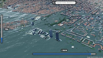
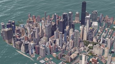
The project, called ‘Sea Level Rise 3D Map’, was created by developer Akihiko Kusanagi. It is an interactive simulation that uses Google Maps’ powerful photorealistic 3D tiles, along with rendering technologies such as deck.gl and three.js. The result is a three-dimensional map that allows users to visualize, in a realistic and dynamic way, how the planet’s coastal geography would change as sea levels rise.
Unlike traditional 2D maps, this tool offers an immersive and alarming experience, where anyone can become a direct witness to the consequences of climate change. In addition, its code is completely open source and available on GitHub, allowing it to be used and improved by the community.
How it works
The Sea Level Rise 3D Map interface is simple yet powerful. Users can adjust two main parameters:
- Sea level: the most important control allows you to gradually increase the water level, meter by meter. With each increase, a blue layer covers the land, starting with port areas and beaches, until it reaches urban areas. It is important to remember that for every centimeter the sea rises, the coastline can recede up to one meter.
- Time of day: a second control adjusts the lighting and shadows of the environment, adding realism and depth to the simulation.
The most striking feature is its integrated search engine, which allows you to move to any point on the planet with 3D coverage on Google. From the Statue of Liberty in New York to Big Ben in London, you can see how they would look underwater in different sea level rise scenarios.
The science behind the map
Although this tool is not intended to be a predictive scientific model, it does put a face and volume to the data that experts have been warning about for years. There are two main causes of sea level rise:
- Thermal expansion, as the oceans have absorbed more than 90% of the additional heat generated by human emissions, causing the water to expand.
- The melting of Greenland, Antarctica, and mountain glaciers, which contribute billions of tons of water to the oceans each year.
According to the IPCC (Intergovernmental Panel on Climate Change), even if global warming were limited to 1.5°C, sea levels would still inevitably rise. Estimates for 2100 range from 43 cm in the best-case scenario to more than 84 cm in the worst-case scenario.
Projects like this are essential to understanding the magnitude of the climate challenge. With just a few clicks, users can visualize what scientists already know: that even a few meters of sea level rise can have devastating consequences.
Beyond the technical impact, this map leaves us with a clear message: what seems like a simulation today could become tomorrow’s reality.
Related stories
Follow MeriStation USA on X (formerly known as Twitter). Your video game and entertainment website for all the news, updates, and breaking news from the world of video games, movies, series, manga, and anime. Previews, reviews, interviews, trailers, gameplay, podcasts and more! Follow us now!
Complete your personal details to comment