Caldor Fire update: affected areas and evacuation map
Wildfires continue to threaten the west coast of the United States with strong winds spreading the blaze to Lake Tahoe and spurring widespread evacuations.
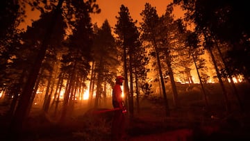

The Caldor Fire continues to force California residents to evacuate from swathes of the state as firefighters look to defend Lake Tahoe from the wildfire. On Tuesday it was announced that the southern end of the alpine resort was being evacuated with other regions across the state line in Nevada being put on notice.
Lake Tahoe usually enjoys a busy summer season but the rapid growth of the Caldor Fire forced tourists and residents to flee on Monday, leaving highways gridlocked and streets deserted. The blaze is currently restricted to El Dorado and Amador counties but there is concern that the current conditions could exacerbate the threat.
The #CaldorFire was measured at 191,607 acres Tuesday morning and remained just 15% contained.
— San Francisco Chronicle (@sfchronicle) August 31, 2021
The fire remained active overnight Monday, Cal Fire said, thanks in part to persistently low humidity. https://t.co/BCOX9TSOT4
NBC Bay Area report that the fire was pushed along by strong winds to cross two major highways and cascade down wooden slopes and into the Tahoe Basin. On Monday evening the Christmas Valley area was under threat and firefighters were dispatched to protect the area, which is just ten miles from the city of South Lake Tahoe.
Details of the latest position of the Caldor Fire are available on the Caldor Fire Structure Status Map, produced by the California Fire Department.
El Dorado county officials have made an Evacuation Map which shows the affected areas, as well as information about shelter locations and road closures in the area.
"It's burning incredibly erratic and it's very scary," @KaynaWhitworth reports.
— ABC News (@ABC) August 31, 2021
For over two weeks, the Caldor Fire has swept across 177,260 acres of Northern California & only 14% of the fire is currently contained, according to U.S. Forest Service. https://t.co/NgVFda1B5a pic.twitter.com/1gCXkus2Lm
Wildfires continue to threaten West Coast
In California, officials representing both Carson City and Douglas County confirmed that community evacuations shelters were at capacity as of Tuesday. Additional sites have been opened in a Carson City park, the Reno Sparks Convention Center, a rodeo event venue in Dayton and Layton County fairgrounds, Yerington.
However despite the best efforts of all involved there is a real concern that the staggering frequency and severity of wildfires this year may soon exhaust local authorities. California in particular has been a hotspot of some of the most dangerous blazes and scientists warn that it will become an increasingly large problem as climate change brings about more extreme heat waves.
Related stories

Currently Caldor covers over 190,000 acres of land and has been burning for 17 days across the Golden State. Most worryingly CalFire officials say that it is just 16% contained, leaving the possibility that it could spread to other regions if the current conditions persist.
The Dixie Fire, the biggest single-origin wildfire in the state’s history, is still raging in northern California and has so far crossed five counties. It has burned through more than 770,000 acres along the west coast and is still only 48% contained as firefighter’s battle against numerous outbreaks.