Flooding advisory in the East Coast: Which areas of New York, New Jersey and Florida will be affected?
Coastal flood warnings are being issued along the East Coast from New York to Florida.
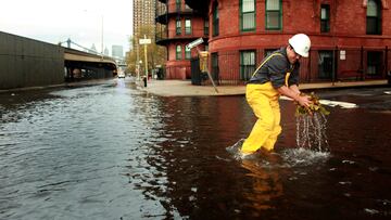

The National Weather Service (NWS) has issued various coastal flood warnings spanning across the East Coast of the US from Florida to New York.
Warnings issued in Florida
A Coastal Flood Advisory has been imposed through 8 pm ET, covering:
- Coastal Palm Beach County,
- Coastal Broward County,
- and Coastal Miami Dade County.
The NWS warns of dangerous rip tides and moderate coastal flooding. Residents might find that the flooding impacts “lots, parks, and roads with only isolated road closures expected.”
Additionally, the Melbourne NWS office issued a warning through 2 pm ET on Sunday, informing residents that “minor coastal flooding” is possible, which also brings a High Rip Current Risk. The areas covered by the alert include:
- Coastal Volusia,
- Brevard,
- Indian River,
- Saint Lucie, and
- Martin counties.
“Rip currents can sweep even the best swimmers away from shore into deeper water,” warns the weather agency.
Warnings issued in Massachusetts
Between 10 am ET and 3 pm ET, an alert is in effect covering:
- Eastern Essex MA,
- Suffolk MA,
- Eastern Norfolk MA,
- Eastern Plymouth MA,
- Barnstable MA,
- Dukes MA
- and Nantucket MA Counties.
Residents can expect “up to one foot of inundation above ground level expected in low-lying areas near shorelines and tidal waterways (3.2 to 13.5 feet Mean Lower Low Water).” Drivers should consider staying off the road as “shallow pockets of flooding less than one foot deep,” can be affected, “including Morrissey Boulevard in Boston.”
Warnings issued in Connecticut, New Jersey, New York
In New Jersey, an alert warning of “up to one foot of inundation above ground level expected in low-lying areas near shorelines and tidal waterways” will be in affect from 7:00 am ET to 1 pm ET, covering:
- Atlantic Coastal Cape,
- Atlantic,
- Cape May,
- Coastal Ocean,
- Cumberland,
- Delaware Beaches
- Eastern Monmouth,
- Kent,
- Inland Sussex,
- May and Coastal Atlantic,
- Middlesex
- Ocean,
- Southeastern Burlington, and
- Western Monmouth.
The flooding could lead to road closures, so drivers should be prepared that their journey may take a little longer on Friday morning.
An alert covering areas in Connecticut Southern Fairfield County and New York’s Southern Westchester and Bronx Counties has been issued through Friday afternoon. The NWS warns that residents should expect “up to one half foot of inundation above ground level [...] in vulnerable areas near the waterfront and shoreline.”
Additionally on Friday, residents in Hudson County, New Jersey, and Manhattan and Richmond (Staten Island) Counties in New York, should expect between one to two feet of flooding “in vulnerable areas near the waterfront and shoreline.” The alert will be in effect from 6 am ET through 10 AM ET on Friday. Similiarly, over the same time period, the agency warns that Kings (Brooklyn), Southern Queens and Southern Nassau Counties could see “up to one half foot of inundation above ground level.”
Warnings issued in North Carolina
In North Carolina, an alert is in effect through noon on Sunday. The NWS has issued three warnings affecting a few different areas.
The first, covers the following areas:
- Areas along Bogue Banks beaches
- Bogue Sound
- the Newport and White Oak Rivers, and adjacent tidal creeks, areas along the lower Neuse River,
- Pamlico,
- Core and Back Sounds, and adjacent tidal creeks, and areas along the beaches,
- Pamlico Sound, and adjacent tidal creeks.
In these areas, the NWS is expecting “up to 1 to 2 feet of inundation above ground level expected in low-lying areas near shorelines and tidal waterways.”
Another alert covering some of the same areas, and a few others, including:
- Areas along the Pamlico Sound,
- Trent,
- Bay and lower Neuse Rivers, and adjacent tidal creeks
Related stories
This alert will end on 11 AM on Saturday. Residents should be prepared for “up to 1 foot of inundation above ground level expected in low-lying areas near shorelines and tidal waterways.”
In the Northern Outer Banks and Hatteras Island, residents should expect “up to 2 feet of inundation above ground level expected in low-lying areas near shorelines and tidal waterways. Waves as high as 5 to 8 feet are also forecasted in the areas’ surf zone. Additionally, if the flooding is not enough of a warning to avoid the beach, the NWS is expecting “dangerous rip currents.” This alert is also in effect through noon ET on Sunday.
Complete your personal details to comment