WATCH what Hurricane Idalia looks like from space
Hurricane Idalia has strengthened to a Category 4 storm as it hurtles its way toward Florida, packing 130 mph winds. Here’s what it looks like from space.
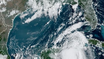

Idalia continues to strengthen and has intensified into an extremely dangerous Category 4 hurricane as it makes its way to the west coast of Florida.
Th International Space Station has sent satellite images of the storm which demonstrate its immensity. The station passed over the hurricane which was whipping over the Gulf of Mexico at 11:25 a.m on Tuesday, and the flyover lasted about 14 minutes.
This video from Space.com uploaded onto their Video From Space YouTube channel shows the massive size of Idalia.
READ ALSO: What is the difference between category 1, 2, 3, 4 and 5 hurricanes?
READ ALSO: Hurricane Idalia in Florida: Areas with evacuation orders
Hurricane Idalia’s powerful winds
The hurricane was packing maximum sustained winds at 130 mph at 5 a.m. ET, and is expected to hit land Wednesday morning.
The weather system is already causing some flooding in the coast, and it is feared that it will cause storm surge that could reach never-before-seen levels along Florida’s Big Bend region.
According to the National Hurricane Center, the surge could reach perilous heights of 12 to 16 feet, depending on the tides.
Related stories


The storm is expected to affect a large part of Florida, including Tampa and Orlando. Governor Ron De Santis has already declared a state of emergency in 46 counties.
Government and weather officials strongly advise residents to follow evacuation orders and keep themselves updated on the hurricane’s movements.