Why does California get so many earthquakes and tremors?
An earthquake struck the Californian coastline today, with tsunami warnings coming soon after.

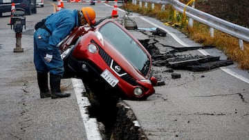
In 2024, a number of earthquakes have hit southern California, one of the areas of the United States that is most vulnerable to seismic events.
Earlier today, a powerful earthquake with a magnitude of 7.3 struck off the coast of Northern California, causing widespread concern and prompting a tsunami warning for the region. The quake occurred at approximately 10:44 a.m. PST / 1:44 p.m ET, about 45 miles southwest of Eureka.
CALIFORNIA EARTHQUAKE: AFFECTED AREAS
🚨#BREAKING: Tsunami sirens and warnings are going off issued for the western coastline after a powerful 7.3 earthquake struck
— R A W S A L E R T S (@rawsalerts) December 5, 2024
📌#California | #Oregon
A powerful magnitude 7.3 earthquake has struck off the coast of California, triggering tsunami sirens and prompting a tsunami… pic.twitter.com/afjDpcsbBZ
4.7 quake strikes near Malibu
Earlier in the year, an earthquake caused shaking in the Malibu area, with its centre located some 7 kilometres (4.3 miles) north of the city. It was measured at a magnitude of 4.7, per the United States Geological Survey (USGS). According to local media, there are no reports of injuries or major damage.
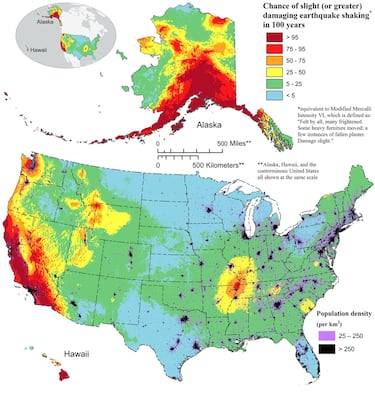
According to the report ‘The 50-State National Seismic Hazard Model’, the possibility of greater quaking in seismically active regions of California is higher compared to other states. Why is this so?
Why are there so many earthquakes and tremors in California?
According to the USGS, this region of the country “has been tectonically active since the supercontinent Pangaea broke up approximately 200 million years ago.”
The agency notes that the high incidence of earthquakes in the state is largely due to the fact that it is located near the western edge of the North American plate.
“The juxtaposition of the Pacific and North American plates has formed many faults in California that accommodate lateral movement between the plates,” the USGS explains. “To the north and east of California, the Basin and Range province between the Wasatch Mountains in Utah and the Sierra Nevada Mountains in eastern California is actively spreading and stretching westward.”

Which areas of the USA are most likely to experience an earthquake?
Although earthquakes cannot be predicted accurately, the National Seismic Hazard Model (NSHM) provides information on the potential seismic risks in the United States.
The NSHM was updated in December of last year for all 50 states using “new science on seismicity, fault ruptures, ground motions, and probabilistic techniques to produce a standard of practice for public policy and other engineering applications.”
Related stories
After analyzing data conducted by more than 50 scientists and engineers, it has been found that nearly 75% of the United States could experience damaging earthquakes.
The NSHM shows the potential for more damaging earthquakes along the central and northeastern Atlantic coastal corridor, including the cities of Washington D.C., Philadelphia, New York, and Boston. However, there is a potential for greater shaking in the seismically active regions of California and Alaska.


Complete your personal details to comment