WEATHER
Storm, flooding and tornado alert in USA: these are the alert zones, May 22
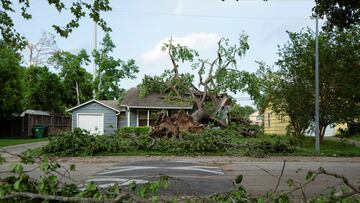
A significant weather event is unfolding across the United States, with storm, flooding, and tornado alerts issued for the north.

Journalist, AS USA
Oli joined the Latest News team in 2021, taking an interest in economics, world news, and articles that build from his study of history. He also dabbles in sports writing, joining the coverage of the last soccer World Cup as well as European Champions League games. He enjoys playing football, electronic music, and painting miniatures.
Update:
A significant weather event is unfolding across the United States, with storm, flooding, and tornado alerts issued for various regions. The National Weather Service has highlighted several areas at risk of severe weather conditions today.
Related stories


In short, severe storms with large hail, damaging winds, and a few tornadoes are likely today in the southern Plains and Ark-La-Tex. Isolated severe storms may also occur in the mid Mississippi Valley, Ohio Valley, and Lower Great Lakes.
A regional storm breakdown
Southern Plains/Ark-La-Tex
- Severe storms expected with large hail and wind damage.
- Cold front advancing southeastward, triggering numerous thunderstorms.
- Potential for supercells with hail over 2 inches and wind damage. Tornadoes possible, especially with supercells.
- Severe threat expected into early to mid-evening as storms move eastward.
Ohio Valley/Lower Great Lakes
- Instability near pre-frontal trough may lead to isolated to scattered thunderstorms.
- Potential for organised severe storms with wind damage primary threat.
- Hail and marginal tornado threat possible in the Lower Great Lakes.
Residents in these areas should stay alert, monitor local weather updates, and follow any advisories or warnings issued by authorities.