The signs that point to the return of ‘El Niño’: When could it arrive?
A satellite has detected Kelvin waves moving towards South America, dragging warm water and rising sea levels, a symptom of the climate phenomenon of El Niño.

Every several years the sky becomes unrecognizable in Colombia. The clouds begin to act in a peculiar and different way. When El Niño passes through South America, it brings with it all kinds of havoc. The same as when it does through Central America and Southeast Asia. This is a phenomenon related to the warming of the Pacific that unleashes rains that are as severe as they are occasional. And sweltering heat is a result of the instability in atmospheric pressure—the culprit of many weather anomalies around the world.
Experts suggest that it can take anywhere from two to seven years for the phenomenon to occur, but recognizing its arrival is not an easy task. It is important to mark the month when El Niño is expected to arrive on the calendar in order to prepare for this unpredictable period. Recently, a satellite has provided valuable information on sea level that could help predict the timing of the arrival of the El Niño.
Moving and warming water
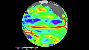
It is the Sentinel-6 Michael Freilich, a device in the shape of a Pyrenean gabled roof that revolves around the planet and has detected a very revealing sign: Kelvin waves, between 5 and 10 centimeters high at the ocean surface and with a width of hundreds of kilometers. And these waves are headed straight to Peru.
Usually, when these waves are generated at the equator, they carry warm water. They do so from the western to the eastern Pacific. And this, in turn, is associated with higher sea levels, which is a symptom of El Niño.
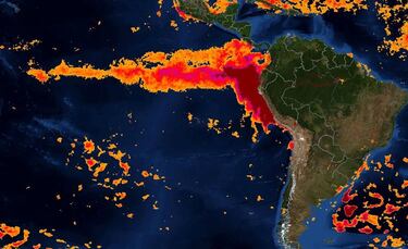
The consequences of the phenomenon differ depending on the area in which it arrives. While cold and wet weather can turn the southwestern United States into a California of umbrellas and cloudy skies. However, in past years, their onset can also simultaneously create a drought in the western Pacific that transforms the Indonesian and Australian skies into a climate more typically seen in a place like Texas.
When could it arrive?
Related stories


The scientists that make up the Sentinel-6 Michael Freilich project have not taken long to speak out. One of them, Josh Willis, reported in a corporate letter that they will be “watching this El Niño like a hawk.” He works at the NASA Jet Propulsion Laboratory, which, curiously enough, is located in California. And its evaluation, as well as that of other administrations, is that El Niño will arrive by the end of the summer.
“If it’s big, the globe will see record warming, but in the southwestern US, we could be looking at another wet winter immediately after the soaking we had the last winter,” stated Willis. The scientist added that when they measure “sea level from space using satellite altimeters, we know not only the shape and height of the water but also its movement.”