Tropical storm Francine path: Where will the potential hurricane hit in Texas or Louisiana?
Francine has strengthened into a tropical storm and threatens to hit parts of Texas and Louisiana in the coming days. Could it make landfall as a hurricane?
During the early hours of Monday, Sept. 9, Tropical Cyclone Francine intensified into a tropical storm as it continues its eastward path. With this, Francine became the sixth named tropical storm of the season.
The National Weather Service has issued several Hurricane Warnings and Watches that include areas in Louisiana and Texas.
The storm brings the risk of flash flooding across the northern coast of Mexico and great risk to the communities along the Texas and Louisiana coasts. The storm is then expected to move north through the United States, which could lead to flooding in certain areas, depending on the trajectory of the storm when it makes landfall.
“Tropical Storm Francine has formed in the Gulf. While the system’s track has shifted eastward and is now expected to approach the Louisiana coast, southeast Texas will continue to experience hazardous marine conditions, coastal flooding, and some heavy rainfall,” the National Weather Service reported.
READ ALSO: Fire in Trabuco Canyon burns hundreds of acres
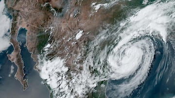
Tropical Storm Francine continues its north-northwest track through the western Gulf of Mexico and remaining offshore. Threats to Deep South Texas include heavy rainfall in the rainbands along the coast, and dangerous surf/marine conditions. #txwx #rgvwx pic.twitter.com/tqWwHdUft7
— NWS Brownsville (@NWSBrownsville) September 10, 2024
When will Francine reach Texas? Will it make landfall as a hurricane?
According to the weather agency, “heavy to excessive rainfall and flooding, life-threatening storm surge and strong winds are expected along the Texas and Louisiana coasts Tuesday through the middle of the week with landfall likely along the Louisiana coast on Wednesday.”
Francine is expected to bring four to eight inches of rain across the Texas coastline as far south as Louisiana and Mississippi. Weather forecasters predict severe weather to begin hitting the country on Tuesday night, Sept. 10, and intensify as the storm moves northeast.
The storm is also expected to become a hurricane shortly before reaching the northwest Gulf Coast of the United States around Wednesday, Sept. 11; therefore, there are warnings for significant flash and urban flooding. Given the path of the phenomenon, the greatest impact is expected to be in Louisiana, so evacuation preparations along the Louisiana coast should already be underway.
Related stories


READ ALSO: Big Lots files for bankruptcy protection
Tropical Storm Watches and Warnings are now in effect for the Coastal Bend and Gulf waters as Tropical Storm Francine has redeveloped a new center of circulation slightly westward. Please continue to monitor the latest forecast for updates. #stxwx #txwx pic.twitter.com/SgffM4IkZf
— NWS Corpus Christi (@NWSCorpus) September 9, 2024
For more information and real-time updates, visit the National Weather Service website.
Complete your personal details to comment