What are alternative routes for travel after the Baltimore bridge collapse?
This morning’s rush hour transformed into a frustrating standstill, and traffic woes are expected to linger for days.


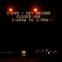
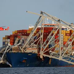
The tragic collapse of the Francis Scott Key Bridge early this morning has thrown Baltimore’s transportation network into chaos. With a vital section of I-695 (Baltimore Beltway) severed, commuters and travelers face significant delays. The Outer Loop of I-695 is closed at Exit 2 and the Inner Loop is closed at Exit 43.
The Baltimore Department of Transportation and the Maryland Transportation Authority are working to establish alternative routes and manage traffic flow. However, significant delays are inevitable.
A breakdown of alternative routes to navigate around the disaster zone
- Interstate 95 (I-95): This north-south freeway offers a viable option for long-distance travel bypassing the affected area.
- Interstate 895 (I-895): This east-west interstate provides a good alternative for travel within the Baltimore metropolitan area. It can be used to circumvent the eastern portion of the Beltway where the bridge collapse occurred.
While these major highways offer some relief for long-distance travel, navigating within Baltimore itself might be a different story. The Fort McHenry Tunnel, a key passage under the harbor, is likely to experience gridlock as it absorbs the overflow from the collapsed bridge.
For shorter trips within the city, especially reaching attractions like Fells Point, consider the Baltimore Water Taxi ferries. Public transportation is another option – the Maryland Transit Administration (MTA) is expected to ramp up bus service to meet the increased demand.
Tips for navigating the delays
Related stories
Who are Synergy Marine Group?
Who was Francis Scott Key?
Arm yourself with a traffic app and local radio updates. These will give you the best knowledge of where traffic is at its worst. Both Google and Apple maps apps also map congestion in real-time.
Another option would be to adjust your schedule! Leaving earlier or later than usual can significantly reduce your commute time. Plan for delays, pack some snacks for the inevitable wait times: road rage won’t make traffic move any faster.