Winter Weather Alert: Which states will see snow storms today, Friday, December 1?
Severe weather is bringing snow and cold temperatures to areas across the US. Will you be impacted on the first day of the twelfth month?
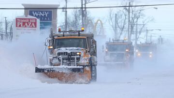
Chilly conditions continue to impact across the United States. It’s essential to examine the weather forecast before heading out in the winter months to guarantee safe travels on the roads. The National Weather Service (NWS) has issued alerts about the harsh weather conditions prevailing in the country presently. It’s crucial to verify if your location falls under the affected areas and to adopt essential measures to stay cozy and secure during this period.
Winter Weather Advisory
The following areas are under Winter Weather Advisory, which the NWS issues “for any amount of freezing rain, or when 2 to 4 inches of snow (alone or in combination with sleet and freezing rain), is expected to cause a significant inconvenience, but not serious enough to warrant a warning.” For the details, please review the information uploaded to the NWS website, which compiles and updates these alerts.
Winter Weather Advisory
IDAHO
Where: Southern Hills/Albion Mountains, Raft River Region, Marsh and Arbon Highlands, Franklin/Eastern Oneida Region, Bear River Range, Bear Lake Valley, Blackfoot Mountains, Caribou Range, Big Hole Mountains, Teton Valley, Centennial Mountains - Island Park, Sawtooth/Stanley Basin.
When: from 5 AM Friday to 5 AM MST Saturday.
What: Snow expected. Total snow accumulations of 1 to 3 inches, except 4 to 10 inches on ridge tops and elevations above passes. Winds gusting as high as 40 mph.
Where: Shoshone/Lava Beds, Arco/Mud Lake Desert, Upper Snake River Plain, Lower Snake River Plain, Eastern Magic Valley.
When: Winter Weather Advisory from 5 AM Friday to 5 AM MST Saturday.
What: Snow expected. Total snow accumulations of up to 3 inches. Winds gusting as high as 40 mph, creating the concern for blowing and drifting snow.
NEVADA:
Where: Southwest Elko County, South Central Elko County.
When: from 10 PM Thursday to 4 PM PST Saturday.
What: Snow expected. Total snow accumulations of 1 to 5 inches. Winds gusting as high as 35 mph.
Where: Humboldt County.
When: Winter Weather Advisory from 4 PM Thursday to 4 PM PST Saturday.
What: Snow expected above 6000 feet. Total snow accumulations of 1 to 10 inches, with up to half an inch in the valleys. Winds gusting as high as 45 mph in high terrain.
Where: White Pine County, Southern Lander County, and Southern Eureka County.
When: Winter Weather Advisory from 10 PM Thursday to 4 PM PST Saturday.
What: Snow expected above 6500 feet. Total snow accumulations of 2-5 inches above 6500 feet, and a trace to 2 inches in the valleys.
OREGON:
Where: Northern Oregon Cascades, Cascades in Lane County, South Washington Cascades.
When: until 4 AM PST early this morning. Winter Storm Warning from 4 AM early this morning to 10 PM PST Saturday.
What: Wet snow. Additional snow accumulations of up to one inch. Winds gusting as high as 35 mph.
MONTANA:
Where: East Glacier Park Region.
When: from 11 AM this morning to 6 PM MST Saturday.
What: Snow and blowing snow expected. Total snow accumulations 2 to 6 inches, with totals in excess of 6 inches above pass level. Winds gusting as high as 40 mph at times.
ARIZONA:
Where: Western Mogollon Rim, Eastern Mogollon Rim.
When: until 11 PM MST this evening.
What: Snow expected above 6500 feet. Additional snow accumulations of 0 to 2 inches from 6500 to 7500 feet. Higher amounts of 2 to 5 inches above 7500 feet.
Where: Kaibab Plateau.
When: until 5 PM MST this afternoon.
What: Snow expected above 7000 feet. Additional snow accumulations of 1 to 2 inches.
Where: White Mountains.
When: until 5 AM MST Saturday.
What: Snow expected above 6500 feet. Additional snow accumulations of 1 to 3 inches from 6500 to 7500 feet. Higher amounts of 3 to 5 inches above 7500 feet.
IDAHO:
Where: West Central Mountains, Boise Mountains.
When: until 5 AM MST Saturday.
What: Total snow accumulations of 3 to 5 inches.
Where: Western Magic Valley, Southern Hills/Albion Mountains.
When: until 5 AM MST Saturday. Winter Storm Watch from late tonight through Sunday afternoon.
What: Snow expected. Total snow accumulations of 1 to 3 inches.
Source: National Weather Service
Winter Storm Warning
The more severe alert issued by the NWS is a Winter Storm Warning, which includes “heavy snow of at least 6 inches in 12 hours, or at least 8 inches in 24 hours, is expected. It can also be issued if sleet accumulation will be at least half an inch.”
Winter Storm Warnings
NEVADA
Northern Elko County, Ruby Mountains, and East Humboldt Range:
Warning Period: From Thursday evening through Sunday morning (until 10 AM PST).
What: Heavy snow, with additional 1-3 feet above 7000 feet, and 0.5-5 inches in valleys below 6500 feet. Winds up to 45 mph.
Where: Northern Elko County, Ruby Mountains, and East Humboldt Range.
Impact: Travel difficult to impossible, reduced visibility, hazardous conditions for morning or evening commute.
COLORADO
West Jackson and West Grand Counties:
Warning Period: From 6 PM Friday to 11 PM MST Sunday.
What: Heavy snow with total accumulations between 14 and 28 inches, and winds gusting up to 55 mph.
Where: Rabbit Ears Pass.
Impact: Travel could be very difficult. Precautions advised.
Elkhead and Park Mountains:
Warning Period: From 5 PM Friday to 5 AM MST Monday.
What: Heavy snow, total accumulations of 1-2 feet, locally higher on favored peaks. Winds up to 55 mph.
Where: Elkhead and Park Mountains.
Impact: Travel very difficult to impossible. Precautions advised.
OREGON
Northern Oregon Cascades, Cascades in Lane County, South Washington Cascades:
Advisory Period: Until 4 AM PST early Friday morning.
Warning Period: From 4 AM PST early Friday morning to 10 PM PST Saturday.
What: Advisory for wet snow above 3000 feet, warning for heavy snow with 10-30 inches above 3000 feet. Winds up to 50 mph.
Where: Northern Oregon Cascades, Cascades in Lane County, South Washington Cascades.
Impact: Travel difficult, reduced visibility, caution advised.
ARIZONA
Chuska Mountains and Defiance Plateau:
Warning Period: Until 5 AM MST Saturday.
What: Heavy snow above 7000 feet, additional 1-4 inches from 6000 to 7000 feet. Total 4-12 inches above 7000 feet.
Where: Areas above 7000 feet near Buffalo Pass, Ganado, and Window Rock.
Impact: Travel could be very difficult, hazardous conditions.
UTAH
Wasatch Mountains I-80 North and Wasatch Mountains South of I-80:
Warning Period: From 11 AM Friday to 5 AM MST Monday.
What: Heavy snow, total accumulations of 20-30 inches. Winds up to 50 mph.
Where: Wasatch Mountains I-80 North and Wasatch Mountains South of I-80.
Impact: Winter driving conditions expected.
Wasatch Back:
Warning Period: From 11 AM Friday to 5 PM MST Sunday.
What: Heavy snow, total accumulations of 8-16 inches, locally higher in the Ogden Valley.
Where: Wasatch Back.
Impact: Travel very difficult, especially in Ogden Valley and along US-40.
WYOMING
Sierra Madre Range and Snowy Range:
Warning Period: From 5 PM Friday to 11 PM MST Sunday.
What: Heavy mountain snow, total accumulations of 10-20 inches, isolated max amounts of 2-3 feet in Sierra Madres.
Where: Sierra Madre Range and Snowy Range.
Impact: Extremely dangerous mountain travel, near-zero visibility, life-threatening outdoor conditions.
Source: National Weather Service
What is the NWS advising today?
Related stories


A multi-day winter storm is set to impact travel in the Northwest, bringing significant mountain snow and heavy rain. Unsettled weather is expected across the eastern third of the country, with heavy rain potential along the Gulf Coast and Southeast, and wintry weather in the Midwest, Great Lakes, and northern New England. The Northwest, Great Basin, and Rockies will experience a fast start to meteorological winter, with heavy mountain snow and rain, particularly in the Pacific Northwest.
Travel disruptions are anticipated, including difficult and hazardous conditions due to heavy snow and blowing snow. The eastern U.S. will experience unsettled and mild weather with light rain, while wintry weather is expected in parts of the Midwest and northern New England. The central and southwestern United States will generally have dry conditions, with below-average temperatures in the central Plains and West and above-average temperatures elsewhere.