Coast-to-Coast Storm Brings Dangerous Threats of Heavy Snow and High Winds
A powerful winter storm continues to bring dangerous threats of heavy snow and high winds, putting parts of more than two dozen states under winter weather alerts

The storm has caused travel conditions to begin deteriorating in some areas. More than 65 million people across 29 states from as far west as California to Minnesota through Maine are under winter weather alerts that caution of a range of impacts, including severe icing, extreme cold, and sleet. These weather conditions are likely to make travel miserable and knock out power to some.
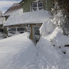
The Upper Midwest is expected to bear the brunt of the storm in terms of snowfall totals, with Minnesota’s Minneapolis area at the highest risk to pick up at least 15 inches of snow. The National Weather Service in Minnesota’s Twin Cities has called this a “historic” three-day storm that will bring widespread accumulating snow, with blowing and drifting snow mainly from Wednesday through Thursday. The worst impacts over the Twin Cities region – which generally includes the cities of Minneapolis, St. Paul, and their surrounding suburbs – are expected to begin late Wednesday into Thursday. Heavy snow is expected to blanket the grounds fairly quickly – and be accompanied by gusty winds, making traveling a life-threatening task for thousands.
In response to the storm, Minnesota Governor Tim Walz has directed the state’s National Guard, the transportation department, and the state patrol to be prepared to respond to storm impacts. He has also urged the public to plan ahead, drive safely, and limit travel.
As of Wednesday, more than 500 flights scheduled for the day have already been cancelled. Among those, Minneapolis and Denver each accounted for more than 100 cancellations, according to the tracking site FlightAware.
In addition to the snow and high winds, more than five million people are under ice storm warnings across northeastern Iowa, southern Wisconsin, northwestern Illinois, and southern Michigan. More than two million people are under blizzard warnings across parts of Wyoming, Minnesota, Wisconsin, and the Dakotas.
Farther west, strong winds from the powerful storm have torn down power lines, knocking out power to more than 140,000 homes and businesses in California. The reported outages occurred in the northern counties of the state, including San Mateo, Santa Clara, and Santa Cruz. California is still bracing for several feet of snow expected in the mountains, with a few inches possible in lower elevations. This unseasonable weather for the Golden State comes nearly two months after rounds of deadly flooding battered many areas.
Conditions in the Midwest Regarding the Storm
Parts of the Upper Midwest could see snowfall at a rate of 1 to 2 inches per hour, combined with wind gusts of 40 to 50 mph, the National Weather Service said. Those expected conditions have put more than two million people under blizzard warnings across parts of Wyoming, Minnesota, Wisconsin, and the Dakotas.
Minneapolis is expected to pick up between 15 and 25 inches of snow by Thursday, in addition to the 1 to 3 inches that have already fallen there. Sioux Falls, South Dakota, is also at high risk, as snowfall up to 16 inches and winds of 45 mph are expected. In Cheyenne, Wyoming, heavy snowfall up to 1 foot is expected in addition to high winds that could feel as cold as 35 below zero.
Icing is also expected in some areas. Milwaukee in Wisconsin and Detroit and Ann Arbor in Michigan are likely to experience icing beginning Wednesday. Meanwhile, severe thunderstorms with damaging winds and rain are expected Wednesday morning through the afternoon in parts of Oklahoma into western Arkansas, across Missouri, and western Illinois, according to the National Weather Service
The storm has led states to take safety measures. South Dakota’s governor announced on Tuesday the closure of state government executive branch offices on Wednesday in more than half of the state’s 66 counties, with plans for employees to work remotely. Additionally, Interstates 29 and 90 partially closed Tuesday night to prepare for the expected snow.
Meanwhile, in Wyoming, several institutions decided to shutter their doors on Wednesday. Eastern Wyoming College announced the closure of its main campus. The Natrona County school district in Casper will conduct a virtual learning day on Wednesday due to hazardous weather and road conditions throughout the area, the district said.
The Food Bank of Wyoming, which says it serves all 23 counties across the state, planned to close on Wednesday, according to a tweet from the organization. A blizzard warning is in effect in part of Wyoming until 11 p.m. on Wednesday.
According to the National Weather Service in Riverton, Wyoming, snow accumulations could reach up to a foot, and winds could gust up to 50 mph. The weather service warns that travel will be impossible in some areas, and frigid wind chills as low as 35 degrees below zero can cause frostbite on exposed skin in as little as 30 minutes.
A blizzard warning is also in effect in parts of North Dakota and Minnesota on Wednesday, with winds gusting up to 50 mph. Wind chills could drop as low as 45 degrees below zero, carrying the risk of causing frostbite in as little as 10 minutes.
The winter storm is also affecting the West Coast of the United States, where parts of Nebraska and Wyoming are under a winter storm warning that will continue until early Thursday morning, with snow of up to 15 inches expected. Wind chills are set to reach as low as 40 degrees below zero. In some parts of Colorado, snow and wind gusts that could reach up to 45 mph are expected, while in Utah, up to a foot of snow and wind gusts of 60 mph are expected.
Iowa weather
Eastern Iowa is currently bracing for the arrival of freezing rain and sleet, with the potential for more widespread activity as the morning progresses. Despite initially being scattered, these weather conditions are expected to lead to the quick formation of glazing on roads and other surfaces due to temperatures ranging from the upper 20s to lower 30s. The resulting dangerous travel conditions have prompted concern from local officials, who are urging residents to exercise caution and take appropriate safety measures.
BREAKING: An Ice Storm WARNING has been issued for @IowaStateU from 6 AM Wednesday morning through 12 PM Thursday for significant icing accumulation of nearly 0.25" or higher.
— Iowa State Weather (@IowaStateWX) February 22, 2023
Up to 1 inch of snow is possible early Thursday morning. pic.twitter.com/DPqWvf8GBm
Detroit weather
A winter storm is expected to impact several counties in Michigan with freezing rain, sleet, and snow. An ice storm warning is in effect for St. Clair, Livingston, Oakland, Macomb, and Washtenaw counties from noon on Wednesday until 4 a.m. on Thursday. Additionally, a winter weather advisory is in effect for Wayne, Monroe, and Lenawee counties from 10 a.m. to 8 p.m. on Wednesday, and a winter storm warning is in effect for Lapeer and Sanilac counties from noon on Wednesday until 4 a.m. on Thursday.
The day will begin with snow, sleet, and possible freezing rain in the morning before changing to a mix of sleet, rain, and freezing rain. Snow and sleet are likely near and north of I-69 through the afternoon, with the northern and western suburbs of Detroit likely to get more freezing rain into the evening. Detroit and areas south have the best chance to warm up enough to return to rain. Road conditions are expected to become very icy, particularly Wednesday evening into Thursday morning, and some areas could receive over 0.25″ of ice. With winds over 25 mph, power outages are likely, particularly late on Wednesday through Wednesday night. Central Michigan through the northern Thumb could receive over 8″ of snow from this storm.
Related stories

The heaviest icing is expected to occur before 11 p.m. on Wednesday, but freezing drizzle will still be possible through the night, and potential power outages due to icing on trees and power lines will be monitored. Thursday will see icy roads in the morning, with a bit of sun in the afternoon. Highs are expected to reach 48° in Detroit and 55° in Monroe, while remaining around 40° north of M59. Wind gusts could reach up to 35 mph.
Impactful winter storm set to bring heavy wintery mixed precipitation through tonight. Heaviest precipitation arrives during the afternoon and evening hours, primarily as a freezing rain south of I-69 (some sleet mixed in) and snow to the north. pic.twitter.com/5nDp2OSeRV
— NWS Detroit (@NWSDetroit) February 22, 2023
Illinois weather
The National Weather Service has expanded the Ice Storm Warning to include Winnebago, Boone, and McHenry Counties, which will be in effect from 6 am on Wednesday until 6 am on Thursday. In addition, Whiteside and Lee Counties have been added to the Winter Weather Advisory. The wintry mix of freezing rain and sleet will pass through the region early in the day and will become more widespread and intense in the mid-morning and throughout the latter half of the day. Forecast models show an elongated period of time in which freezing rain could be the primary precipitation. There may be regular rain that falls, which could limit the potential for roads to become slick and icy ahead of the evening commute. If more freezing rain occurs, accumulations for extreme northern Illinois and southern Wisconsin will likely end up in the range of .10″ to .50″. These significant ice accumulations are enough to cause most roads to be icy and cause a few power outages. Therefore, it’s recommended to avoid being on the roads during this time and to have a kit ready if you must be out. The precipitation will become lighter and more scattered as the storm system moves into Wednesday night and into Thursday. The strong winds on Thursday could result in further tree and power line damage. The cold air rushing in on Thursday will cool temperatures for Friday, with highs in the low 20s, but temperatures are expected to climb back towards the 40-degree mark by Saturday morning.
D1
— LimWx (Off Season from Hurricanes) (@LimWeather) February 22, 2023
High risk in S #Michigan
MDT risk in E #Iowa, S #Wisconsin, N #Illinois esp near #Chicago, #KenoshaWI, #Rockford, #Dubuque, #AnnHarbour, W of #Detroit, #Kalamazoo, #SouthBend, #Toledo#USwx #MIwx #IAwx #Winterwx #winterstorm #ice #Freezingrain #icestorm #ILwx #WIwx #OHwx #INwx pic.twitter.com/0MzwhHYv7w