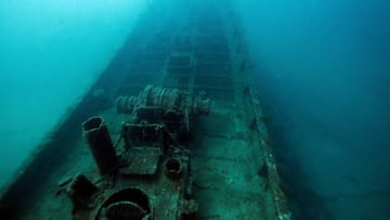
Where is the ship which alerted Titanic of icebergs located?
One of the last ships to warn the Titanic of icebergs that would send the unsinkable ship to the bottom of the ocean was located on the Irish Sea floor.

The Titanic received seven warnings about icebergs on the fateful day that saw the unsinkable ship find itself at the bottom of the ocean on its maiden voyage just a few hours after striking one. One of those warnings on 14 April 1912 came from the SS Mesaba which itself ended up on resting on the sea floor six years later.
The merchant ship was torpedoed without warning by a German U-boat while sailing from Liverpool to Philadelphia sinking to the bottom of the Irish Sea. While the hull of a ship believed to be the SS Mesaba had been located researchers have now positively identified the wreck using a new technique.
Also see:
State-of-the art multibeam sonar “game changer” for marine archaeology
Researchers at Bangor University used state-of-the art multibeam sonar to positively identify the SS Mesaba. It is was sunk in the St George Channel and is among the 273 shipwrecks lying in Irish Sea.
The researchers scanned the 7,500 square miles of the sea and cross-referenced what they observed against the UK Hydrographic Office’s database of wrecks among other sources. The new technique enabled the identification of many more wrecks than the 101 that were thought to be unidentified. The SS Mesaba, like many other sunken vessels in the Irish Sea, had been misidentified in the past.
The research findings have been detailed in a new book, Echoes from the Deep. “The results of the work described in the book has validated the multidisciplinary technique employed,” said Dr Innes McCartney, the book’s author. “[Multibeam sonar] is a ‘game-changer’ for marine archaeology.”
The new technique will allow far more detailed seabed mapping, revealing superstructure details on the sonar images. Multibeam sonar will do for marine archeology what aerial photography did for landscape archeology according to the researchers.
The ship that sent an iceberg warning to the #Titanic has been identified lying in the Irish Sea. SS #Mesaba was a merchant vessel that got torpedoed and sank in1918. Now @BangorUni experts have located it by using multibeam sonar. #archaeology #underwater https://t.co/MIF6Kio7b3 pic.twitter.com/DL1mdKgsRU
— Archaeology & Arts (@archaiologia_en) September 27, 2022
New technology will help reduce costs, speed up exploration
Dr McCartney feels that the multidisciplinary technique will be of much interest to a wide range of groups beyond maritime archaeologists. These include environmental agencies, heritage managers, historians, hydrographers and marine scientists.
“Previously we would be able to dive to a few sites a year to visually identify wrecks. The Prince Madog’s unique sonar capabilities has enabled us to develop a relatively low-cost means of examining the wrecks. We can connect this back to the historical information without costly physical interaction with each site,” he said.
Related stories
“The ‘Prince Madog’ enable us to deliver high quality scientific research in an extremely cost-effective manner,” added Dr Michael Roberts, who led the sonar surveys at the University’s School of Ocean Sciences. “Identifying shipwrecks such as those documented in the publication for historical research and environmental impact studies is just one example of this.”
“We have also been examining these wreck sites to better understand how objects on the seabed interact with physical and biological processes, which in turn can help scientists support the development and growth of the marine energy sector.”


