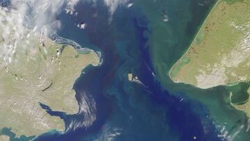
Where are the Diomede Islands? What is the US-Russian border there?
There is one place where the US and Russia are separated by a mere two-mile stretch of water. The Diomede Islands, also once known as the “Ice Curtain”.

The Russian mainland and mainland Alaska are separated by span of water measuring about 55 miles. However, there is one spot out in the middle of that stretch of water where in the winter you can walk across the border separating Russia and the US.
When the US purchased Alaska from Tsarist Russia, the two nations drew a line between two small islands in the Bering Sea to designate the boundary. The distance between Big Diomede, which is on the Russian side and Little Diomede on the US side, is roughly 2.4 miles. The border also serves as the International Date Line.
Also see:
- Ukraine crisis: live updates
- How would a Russian invasion of Ukraine affect the US?
- Mistranslation from Ukrainian president told media war was imminent
- Biden warns Putin in last-ditch phonecall
Two islands, two nations: the Diomede Islands become US-Russian border
The Danish navigator Vitus Jonassen Bering is credited with being the first European visitor to the islands in 1728. His expedition discovered the islands on 16 August which is St Diomede’s Day in the Russian Orthodox Church thus the islands’ names. However, in Russian they are called the Gvozdeva Islands after Mikhail Gvozdev who determined longitude and latitude for the two islands four years later.
The US acquired Little Diomede, also known as Krusenstern Island, as part of the Alaska Purchase in 1867 from Tsarist Russia. Seeing that its possessions along the Pacific coast of North America would be difficult to defend and in financial straits after the Crimean War, Russia offered to sell Alaska to the US.
Despite being only two miles apart, each the Diomede Islands lay in two different countries and two different days of the week. https://t.co/gCutjPGtvb https://t.co/xSupCXl897 pic.twitter.com/mgN252htWd
— The Big Data Stats (@TheBigDataStats) July 18, 2021
Although it received wide approval at the time, skeptics of the deal called it “Seward’s Folly.” The Secretary of State at that time William Seward negotiated with the Russian minister in the US Edouard de Stoeckl to purchase Alaska for $7.2 million, around $137 million in today's money. Vindication of the purchase came in 1896 when a major gold deposit was discovered in the Yukon sparking the Klondike Gold Rush.
The “Ice Curtain”
Big Diomede and Little Diomede were sparsely populated until the Cold War. Up to 1948, families lived on both islands and could visit each other freely, crossing the roughly two and a half miles of water by boat and when the span freezes over in winter by foot. That year the Soviet military set up a base on Big Diomede, also known as Ratmanov Island, and the islanders were forcibly resettled on the Siberian mainland.
Update for 28 July. Surreal photo of the Diomede Islands, part Russia, part U.S. http://t.co/Du9TdqY201 pic.twitter.com/QrYR0ExPvt
— USCGC Healy (@cgchealy) August 4, 2014
In 1988, the official spokesman for Mikhail Gorbachev referred to the boundary between Alaska and Russia as the “Ice Curtain” in a spin on the political and ideological barrier in Europe termed the "Iron Curtain" that separated the Soviet Union and the countries in its sphere of influence from the West during the Cold War.
Related stories
Islanders had hoped to be able to reunite with their cousins on the other side of the border when the Cold War ended. However, tensions have risen between the US and Russia over Ukraine since the Russian invasion of the Crimean Peninsula and subsequent annexation. Which was followed by a second invasion in the east of Ukraine and continued military support for separatists in the region.
The prospect of a thawing of the “Ice Curtain” looks to be even more distant now with tension ratcheting up even more, with warnings that Russia could once again invade Ukraine any day now.


