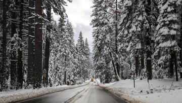
What is the ‘lake effect’? How much snow is expected in Buffalo and western New York State?
The phenomenon is a result of cold winds from Canada reacting to the local geography and it threatens to dump 4ft of snow on parts of the region.

Forecasters have warned that the heavy snow recorded in western parts of New York state will continue through Thursday night and into the weekend.
A sustained spell of “paralyzing” snowfall has hit the region as a result of phenomenon known as the ‘lake effect’. Areas around Buffalo and Watertown are expected to be the worst hit and will likely receive up to 4ft of snow.
“This will be the start of a prolonged lake effect snow event which will likely include paralyzing snowfall for the Buffalo and Watertown areas late this week through the weekend,” said the National Weather Service in Buffalo.
Jon Hitchcock, a meteorologist based in Buffalo, has warned that the worst is probably still to come: “Friday looks to be the worst day for the city [of Buffalo] as snow will be intense and fall at the rate of two to three inches per hour.”
New York Gov. Kathy Hochul declared a state of emergency starting Thursday in parts of western New York ahead of a potentially dangerous bout of lake-effect snow. https://t.co/trICs01BZc
— The Associated Press (@AP) November 17, 2022
What is the lake effect of snowfall?
Periods of heavy snowfall, caused by the lake effect, are often recorded in this part of the country and are due to the unique geographical location. As winter draws in cold air begins to move south from Canada, where it encounters Lake Erie and Lake Ontario.
The lakes’ waters are comparatively warm at this time of year and it heats the cooler gusts, causing the air to rise. This process, occurring over the lakes, forms clouds that cool rapidly as they rise.
Winds continue to agitate the clouds and tend to push them into the area east of the lakes, where they begin dumping enormous amounts of snow. The entire region is braced for 2-3ft of snow in the coming days, with worst-hit areas getting up to 4ft.
In addition to the snowfall, the strong winds that spark the phenomenon can also cause damage and make travel conditions particularly dangerous. On Friday wind speeds are expected to reach 35 mph, whipping up the recently settled snow and reducing visibility considerably.
As we approach Thanksgiving, when millions of Americans are expected to embark on long journeys, the timing could scarcely be worse. New York Gov. Kathy Hochul has imposed a state of emergency across 11 counties in the state as a result of the heavy snowfall.
Related stories


“This is considered an extreme event,” she said during a press briefing Thursday morning. “That means it’s dangerous. That also means it’s life-threatening.”
The Buffalo weather service has advised: “Some major roadways could temporarily close… The hazardous conditions will impact the Friday morning and evening commutes.”