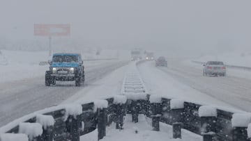
Winter Storm Blair: These are the areas where snow and the lowest temperatures are expected today, Monday, Jan. 6
Since it hit the United States over the weekend, Winter Storm Blair has caused major disruption across a large section of the country.


A severe winter storm affecting a 1,300-mile swathe of the Untied States is set to continue moving eastwards today, Monday January 6, with the country’s National Weather Service warning of “major impacts” in several states in the Mid-Atlantic.
Known as Storm Blair, the extreme weather front has caused states of emergency to be called in seven states in the US: Arkansas, Kansas, Kentucky, Missouri, New Jersey, Virginia and West Virginia.
Where has the snowfall been heaviest?
In Kansas, one of the US’s worst-affected states so far, the city of Chapman has experienced the most significant levels of snowfall as things stand. Per the Weather Channel, Chapman has seen 18 inches of snow since Storm Blair hit the US over the weekend.
The product of what is known as an “arctic outbreak”, the storm has led to power outages, the closure of schools and offices, and travel disruption.
Flights have been cancelled - with more than 1,600 scrubbed so far on Monday, per FlightAware - and motorists have found themselves stranded. The Associated Press has reported that the National Guard had to be activated to come to the aid of stranded vehicles in the state of Indiana.
What is an artic outbreak?
An arctic outbreak is defined by the NWS as a “very cold air masses that typically originate in the Siberian Region of Asia, cross over the north pole into Canada and push south and east into the lower United States”.
What does the National Weather Service forecast for Monday?
According to the NWS’s Weather Prediction Center, “moderate to heavy” snowfall is expected from the Ohio Valley to the Mid-Atlantic on Monday. “The snow will continue into late Monday night over the Mid-Atlantic,” the agency adds.
In the Mid-Atlantic region, the NWS forecasts “considerable disruptions to daily life” in Delaware, Maryland, West Virginia, Virginia and Washington, DC. Six to 12 inches of snow are expected across the Mid-Atlantic, with the NWS warning: “Travelers should anticipate significant disruptions”.
A major winter storm will continue to move through the Mid-Atlantic region today, followed by dangerously cold temperatures spreading across the central and eastern U.S. pic.twitter.com/sogRlbC6Y9
— NWS Weather Prediction Center (@NWSWPC) January 6, 2025
Will Congress close today?
The Office of Personnel Management says federal offices will be closed in Washington, DC, but it is expected that the US Congress will remain open for what is a key date in its calendar. Today, lawmakers are set to gather in Congress to certify the results of November’s US presidential election, in which Republican candidates Donald Trump and JD Vance were elected as president and vice-president, respectively.
The NWS’s Weather Prediction Center also predicts two to four inches of snow today in parts of the Ohio Valley and the Central Appalachians.
“Dangerous” temperatures forecast
In addition, the agency warns of “dangerously cold temperatures” in areas affected by Storm Blair.
In the Mid-Atlantic, temperatures are expected to drop into the teens, with daytime highs around freezing. From the Central Plains to the Ohio Valley, moreover, temperatures are predicted to be below freezing at their highest daytime point, and may slip into single-digit figures.
Related stories
Get your game on! Whether you’re into NFL touchdowns, NBA buzzer-beaters, world-class soccer goals, or MLB home runs, our app has it all.
Dive into live coverage, expert insights, breaking news, exclusive videos, and more – plus, stay updated on the latest in current affairs and entertainment. Download now for all-access coverage, right at your fingertips – anytime, anywhere.


Complete your personal details to comment