Winter Weather Alert: Which states will see snow storms today, Christmas Eve, Sunday December 24?
Winter weather will be affecting communities across the country creating hazardous conditions in some areas. Check out the full list of NWS alerts.
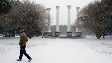
Cold temperatures and snow are creating dangerous conditions around the country. The National Weather Service (NWS) has issued dozens of alerts. If you live in an affected area, it is advised that you take the proper precautions to stay safe. We have compiled all of the current winter alerts active for Christmas Eve, Sunday 24 December, and for the full details, check out the NWS website.
What is a Winter Weather Advisory?
The NWS issues a Winter Weather Advisory “for any amount of freezing rain, or when 2 to 4 inches of snow (alone or in combination with sleet and freezing rain), is expected to cause a significant inconvenience, but not serious enough to warrant a warning.” For the details, please review the information uploaded to the NWS website, which compiles and updates these alerts.
What is a Winter Storm Warning?
The more severe alert issued by the NWS is a Winter Storm Warning, which includes “heavy snow of at least six inches in 12 hours, or at least eight inches in 24 hours, is expected. It can also be issued if sleet accumulation will be at least half an inch.”
What is a Freezing Fog Advisory?
The NWS issues a Freezing Fog Advisory when visibility is below one mile in freezing fog. Low visibility can make driving conditions hazardous. Freezing fog will also lead to icy spots on roadways, especially on elevated surfaces such as overpasses and bridges.
What is an Ice Storm Warning? A Blizzard Warning?
Related stories

The NWS also issues other severe weather alerts: one is called an Ice Storm Warning, where ice accumulation of at least one-fourth of an inch is expected, while a Blizzard Warning is given when blizzard conditions are expected for at least three hours.
Alaska
Winter Weather Advisory:
- Western Arctic Coast, Eastern Beaufort Sea Coast (until Dec. 24 6 p.m. AKST)
- Shishmaref, Bering Strait Coast (until Dec. 24 9 p.m. AKST)
- Dalton Highway Summits, White Mountains and High Terrain South of the Yukon River (until Dec. 24 6 p.m. AKST)
- Copper River Basin, Western Kenai Peninsula (until Dec. 24 9 a.m. AKST)
Winter Storm Warning:
- Haines Borough and Klukwan; Municipality of Skagway, (until Dec. 24 6 a.m. AKST)
- Lower Yukon and Innoko Valleys (until Dec. 24 3 p.m. AKST)
- Western Prince William Sound (until Dec. 24 3 a.m. AKST)
Avalanche Warning: East Turnagain Arm; Western Prince William Sound (until Dec. 24 6 a.m. AKST)
The backcountry avalanche danger is HIGH. Very dangerous avalanche conditions exist. Heavy snowfall and strong winds will create widespread areas of unstable snow. Both human triggered and natural large avalanches are likely. Debris from avalanches above may run into valley bottoms. Avalanche conditions will remain very dangerous immediately after the snow finishes.
Colorado
Winter Storm Warning:
- Eastern San Juan Mountains Above 10000 Ft (until Dec. 24 5 a.m. MST)
- Kit Carson County; Yuma County, Northern Sangre de Cristo Mountains Between 8500 And 11000 Ft; Northern Sangre de Cristo Mountains above 11000 Ft; Southern Sangre De Cristo Mountains Above 11000 Ft; Southern Sangre De Cristo Mountains Between 7500 and 11000 Ft (until Dec. 24 5 p.m. MST)
Winter Weather Advisory:
- Elkhead and Park Mountains; Flat Tops; Gore and Elk Mountains, Central Mountain Valleys; Grand and Battlement Mesas; West Elk and Sawatch Mountains, Northwestern San Juan Mountains, Jefferson and West Douglas Counties Above 6000 Feet, Gilpin, Clear Creek, Northeast Park Counties Below 9000 Feet; Larimer and Boulder Counties Between 6000 and 9000 Feet, Elbert, Central and East Douglas Counties Above 6000 Feet, North and Northeast Elbert County Below 6000 Feet, North Lincoln County; Southeast Elbert County Below 6000 Feet, South Lincoln County; Washington County, Phillips County; Sedgwick County, Pikes Peak above 11000 Ft; Teller County, Rampart Range above 7500fT, Pike's Peak Between 7500 And 11000 Ft, Colorado Springs Vicinity, Southern El Paso County, Rampart Range Below 7400 Ft; Crowley County; La Junta Vicinity, Otero County; Northern El Paso County, Monument Ridge, Rampart Range Below 7500 Ft; Pueblo Vicinity, Pueblo County Below 6300 Feet; Walsenburg Vicinity, Upper Huerfano River Basin Below 7500 Ft, Eastern Kiowa County; Lamar Vicinity, Prowers County; Las Animas Vicinity, Bent County; Western Kiowa County (until Dec. 24 11 a.m. MST)
- South and East Jackson, Larimer, North and Northeast Grand, Northwest Boulder Counties Above 9000 Feet; South and Southeast Grand, West Central and Southwest Boulder, Gilpin, Clear Creek, Summit, North and West Park Counties Above 9000 Feet, Eastern Sawatch Mountains above 11000 Ft; Western Chaffee County Between 9000 and 11000 Ft; Western Mosquito Range, East Lake County Above 11000 Ft, La Garita Mountains Above 10000 Ft; Upper Rio Grande Valley, Eastern San Juan Mountains Below 10000 Ft (until Dec. 24 5 a.m. MST)
- Cheyenne County, Wet Mountain Valley Below 8500 Ft, Wet Mountains above 10000 Ft; Wet Mountains between 6300 and 10000Ft (until Dec. 24 5 p.m. MST)
- Logan County (until Dec. 24 10 a.m. MST)
Kansas
Winter Weather Advisory:
- Cheyenne; Sherman, Greeley; Rawlins; Sherman; Wallace (until Dec. 24 6 p.m. CST)
- Cloud, Marshall; Washington, Mitchell; Osborne; Rooks (until Dec. 26 6 p.m. CST)
Winter Storm Watch:
- Decatur; Norton, Jewell; Phillips; Smith (until Dec. 27 6 a.m. CST)
- Republic (until Dec. 27 6 p.m. CST)
Nebraska
Winter Weather Advisory:
- Dundy; Hitchcock, Sheridan, Eastern Cherry, Blaine; Brown; Keya Paha; Rock, Deuel; Garden, Arthur; Chase; Grant; Hayes; Hooker; Keith; Lincoln; Logan; McPherson; Perkins; Thomas, Western Cherry (until Dec. 24 6 p.m. CST)
- Cheyenne; Morrill (until Dec. 24 12 p.m. CST)
Blizzard Warning
- Adams; Buffalo; Dawson; Gosper; Greeley; Hall; Howard; Kearney; Merrick; Nance; Phelps; Sherman; Valley, Eastern Cherry, Blaine; Brown; Keya Paha; Rock, Custer; Garfield; Holt; Loup; Wheeler, Arthur; Chase; Grant; Hayes; Hooker; Keith; Lincoln; Logan; McPherson; Perkins; Thomas, Frontier, Western Cherry, Antelope; Boone; Cedar; Knox; Madison; Pierce; Platte; Stanton; Wayne (until Dec. 27 6 a.m. CST)
New Hampshire
Winter Weather Advisory: Belknap; Cheshire; Eastern Hillsborough; Merrimack; Northern Grafton; Southern Carroll; Southern Grafton; Sullivan; Western And Central Hillsborough (until Dec. 24 9 a.m. EST)
New Mexico
Winter Weather Advisory: Johnson and Bartlett Mesas Including Raton Pass (up to Dec. 24. 12 p.m. MST)
New York
Winter Weather Advisory:
- Eastern Schenectady; Montgomery; Northern Saratoga; Northern Warren; Northern Washington; Schoharie; Southeast Warren; Southern Fulton; Southern Herkimer; Southern Saratoga; Southern Washington; Western Albany; Western Greene; Western Schenectady; Western Ulster, Eastern Clinton; Eastern Essex; Northern Franklin; Northern St. Lawrence; Southeastern St. Lawrence; Southern Franklin; Southwestern St. Lawrence; Western Clinton; Western Essex, Delaware; Madison; Northern Oneida; Otsego; Southern Oneida; Sullivan (until Dec. 24 10 a.m. EST)
- Orange (until Dec. 24 9 a.m. EST)
Pennsylvania
Winter Weather Advisory: Northern Wayne (until Dec. 24 10 a.m. EST)
South Dakota
Winter Weather Advisory: Bennett; Mellette; Southern Jackson; Todd, Tripp (until Dec. 24 5 p.m. MST)
Blizzard Warning: Aurora; Beadle; Bon Homme; Brule; Charles Mix; Davison; Douglas; Gregory; Hanson; Hutchinson; Jerauld; Sanborn; Yankton, Tripp (until Dec. 26 5 p.m. MST)
Wyoming
Winter Weather Advisory:
- Green Mountains and Rattlesnake Range, Natrona County Lower Elevations (until Dec. 24 8 a.m. MST)
- Lander Foothills; Wind River Basin (until Dec. 24 5 a.m. MST)
- Converse County Lower Elevations; North Laramie Range, Central Carbon County; Central Laramie Range and Southwest Platte County; Ferris, Seminoe, Shirley Mountains; Laramie Valley; North Snowy Range Foothills; Shirley Basin; Sierra Madre Range; Snowy Range; South Laramie Range; Upper North Platte River Basin (until Dec. 24 11 a.m. MST)
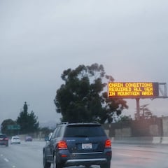
It’s important to keep yourself updated with the latest weather alerts. To get the full details, you can visit the NWS website. In most cases, these warnings will advise you to stay off the roads or take necessary precautions. For instance, make sure to give yourself extra time to reach your destination as the roads might be slippery and require you to slow down at certain points. When you’re not on the road, it’s also important to be cautious while walking on walkways, sidewalks, and paths as they can become icy and increase the risk of injuries.