These are the US cities with the highest risk of extreme weather conditions this weekend
Central and southern United States will experience heavy rain this weekend. Find out which cities are most at risk of facing severe weather conditions.

Severe weather continues to hit parts of the United States, with several areas of the country experiencing heavy rain and possible tornadoes this weekend.
According to the National Weather Service (NWS) Weather Prediction Center, an active stretch of heavy rain is looming over central and southern parts of the country as multiple weather systems move in. Storms will become widespread during the weekend.
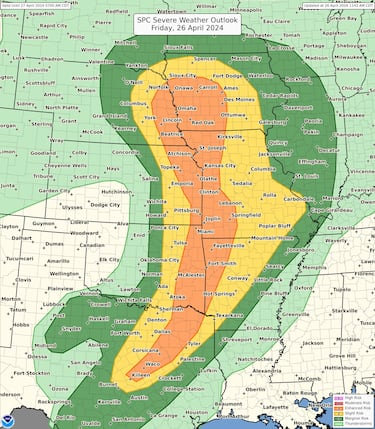
According to the forecast, Dallas, Texas; Kansas City, Missouri; Des Moines, Iowa; and Omaha, Nebraska, are just some of the cities that could be affected by severe thunderstorms through Sunday.
READ ALSO: Viral video of Lufthansa plane bouncing off LAX runway confirmed to be training flight
An active stretch of heavy rainfall is on deck over the Central & Southern U.S as multiple storm systems spawn widespread ⛈️ through the weekend. Significant heavy rainfall is increasingly likely this Saturday across OK, where a Moderate Risk of Excessive Rainfall is highlighted. pic.twitter.com/A4KV3Q5iKo
— NWS Weather Prediction Center (@NWSWPC) April 25, 2024
Heavy rains in the Plains, Mississippi Valley and Midwest on Friday
Thursday’s rains extend to Friday, mainly in eastern Nebraska and Kansas, moving eastward to Iowa and Missouri during the afternoon and evening. According to the Weather Prediction Center, there is a level 3 out of 5 risk of severe thunderstorms for those states.
Damaging winds and large hail, as well as tornadoes, are also possible. Heavy rain can cause flooding.
“Stay informed about the weather today (4/26). There is a broad risk of severe weather from the mid-Missouri Valley to northeast Texas. All severe hazards are possible this afternoon and night, including a pair of strong tornadoes and hail greater than 2 inches,” the center warned.

READ ALSO: Taiwan to benefit from $95 billion US foreign aid package
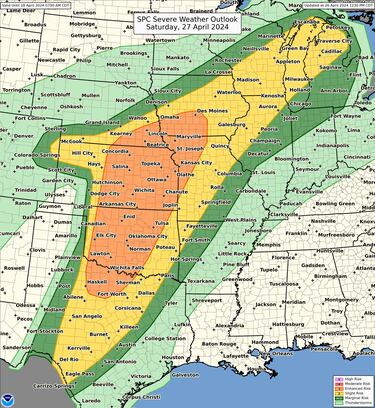
Heavy rain continues on Saturday, with risk of flooding
The storm is expected to continue on Saturday. According to the weather center, some locations could see up to 127 mm of rain in a short period, which could lead to dangerous flash flooding.
A level 3 to 4 risk of excessive rainfall is active for much of Oklahoma, including Oklahoma City and Tulsa.
“Another active day of severe weather is expected across a wide area tomorrow (4/27). There is great potential from the Great Lakes to central Texas. Tornadoes (some strong), hail (some larger than 2 inches), and damaging winds are possible. Stay informed about the weather and check back for updates,” the center announced.

Sunday will see more rain
Related stories
More damaging storms could hit from Texas to Wisconsin on Sunday. Storms could deliver damaging gusts of wind and hail, as well as produce flooding. The weather is expected to improve on Monday.
To be prepared, we advise you to consult the website of the National Weather Service, where you can find out about the alerts that are active near you. On the site, you can see the alert map instantly, as well as filter the information by status.


Complete your personal details to comment