Winter Weather Alert: Which states will see snow storms today, Saturday, December 2?
Severe weather is hitting many western states... check the latest weather advisories issued by the weather service.
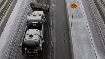

The United States is currently experiencing cold weather conditions impacting different regions. Therefore, it is highly recommended to check the weather forecast before embarking on a winter journey to ensure safe road travel. The National Weather Service has issued alerts regarding the severe weather conditions nationwide. It’s essential to confirm if your location is under the affected areas and take necessary precautions to stay warm and secure during this period. Kindly note the Winter Weather Advisory.
The following areas are under Winter Weather Advisory, which the NWS issues “for any amount of freezing rain, or when 2 to 4 inches of snow (alone or in combination with sleet and freezing rain), is expected to cause a significant inconvenience, but not serious enough to warrant a warning.” For the details, please review the information uploaded to the NWS website, which compiles and updates these alerts.
Winter Weather Advisory
COLORADO
North Park, and Grand and Summit Counties Below 9000 Feet | Active from 8 PM this evening to 11 PM MST Sunday.
Rocky Mountain National Park and the Medicine Bow Range, and The Mountains of Summit County, the Mosquito Range, and the Indian Peaks | Active until 8 PM MST this evening.
Western Mosquito Range above 11000 feet and the Eastern Sawatch Mountains above 11000 feet | Active from 2 PM Saturday to 5 PM MST Sunday.
Grand and Battlement Mesas | Active until 5 AM MST Saturday.
West Elk and Sawatch Mountains | Active until 5 AM MST early this morning.
Upper Yampa River Basin | Active from 11 PM this evening to 5 PM MST Sunday.
Gore and Elk Mountains/Central Mountain Valleys | Active from 5 PM this afternoon to 5 AM MST Monday.
IDAHO
Eastern Magic Valley, the Snake River Plain and across the Arco Desert towards Shoshone | Active until 5 PM MST this afternoon.
Upper Weiser River zone | Active until 11 AM MST this morning.
MONTANA
West Glacier Region | Active until 5 PM MST this afternoon.
Kootenai/Cabinet Region | Active until 5 PM MST this afternoon
Bitterroot/Sapphire Mountains | Active until 5 PM MST this afternoon.
Flathead/Mission Valleys | Active until 5 PM MST this afternoon.
I-90 East Missoula to Bearmouth, Bitterroot Valley, Highway 200 Bonner to Greenough, Missoula, and Highway 83 Seeley Lake to Condon | Active from 11 AM this morning to 8 PM MST this evening.
Southern Rocky Mountain Front | Active from 9 AM this morning to 6 PM MST this evening.
Northwest Beaverhead County | Active from 9 AM this morning to 6 PM MST this evening.
East Glacier Park Region | Active until 6 PM MST this evening.
NEVADA
Southwest Elko County and South Central Elko County | Active through 4 PM PST Saturday.
Humboldt County | Active though 4 PM PST Saturday.
White Pine County and Southern Lander County and Southern Eureka County | Active through 4 PM PST Saturday.
OREGON
Southern Blue Mountains of Oregon | Active until 4 AM PST Sunday.
Ochoco-John Day Highlands | Active until 4 AM PST Sunday.
Klamath Basin | Active until 10 AM PST Saturday.
UTAH
Central Mountains | Active until 5 AM MST Sunday.
Eastern Box Elder County, Northern Wasatch Front, Cache Valley/Utah Portion and Bear Lake and Bear River Valley | Active until 11 AM MST Sunday.
Salt Lake Valley and Utah Valley | Active until 5 AM MST Sunday.
WASHINGTON
Olympic mountains and valleys, including Hurricane Ridge, Amanda Park, and Quinault | Active until 4 PM PST this afternoon.
Portions of North and North Central Idaho and North Central, Northeast, and Southeast Washington | Active until 4 PM PST Saturday.
Wenatchee, Mansfield, Wilbur, Number 1 Canyon, Cashmere, Ritzville, Coulee City, Chelan, Entiat, Number 2 Canyon, Waterville, Pangborn Airport, Grand Coulee, Creston, and Badger Mountain Road | Active until 4 PM PST Saturday.
WYOMING
Southwest Carbon County and Upper North Platte River Basin | Active from 5 PM this afternoon to 11 PM MST Sunday.
Source: National Weather Service
Winter Storm Warning
The more severe alert issued by the NWS is a Winter Storm Warning, which includes “heavy snow of at least 6 inches in 12 hours, or at least 8 inches in 24 hours, is expected. It can also be issued if sleet accumulation will be at least half an inch.”
Winter Storm Warning
COLORADO
Elkhead and Park Mountains | Active until 5 AM MST Monday.
Rabbit Ears Pass | Active through 6 PM this evening to 11 PM MST Sunday.
Rocky Mountain National Park and the Medicine Bow Range, and The Mountains of Summit County, the Mosquito Range, and the Indian Peaks | Active from 6 PM Friday evening to 8 PM MST Saturday. For the Winter Storm Warning, from 8 PM Saturday to 11 PM MST Sunday.
IDAHO
West Central Mountains, Boise Mountains and Camas - Prairie zones | Active until 5 PM MST Sunday.
South Hills, Raft River Region, East and Southeastern Highlands, the Sawtooths and Stanley Basin | Active from 5 AM Saturday to 5 AM MST Monday.
The Sun Valley area | Active from 5 AM Saturday to 5 AM MST Monday.
MONTANA
Highway 11 Pierce to Headquarters, Pierce, Highway 12 | Active until 4 PM PST Saturday.
Lower Clark Fork Region | Active until 5 PM MST Saturday.
NEVADA
Northern Elko County and Ruby Mountains and East Humboldt Range | Active through Sunday morning.
OREGON
Upper Slopes of the Eastern Washington Cascades Cres | Active until 10 AM PST Sunday
In Oregon, Northern Blue Mountains of Oregon. In Washington, Northwest Blue Mountains | Active until 10 AM PST Sunday.
East Slopes of the Oregon Cascades | Active until 4 PM PST Saturday.
Lower Slopes of the Eastern Washington Cascades Crest | Active until 4 AM PST Sunday
In Oregon, Northern Oregon Cascades and Cascades in Lane County. In Washington, South Washington Cascades | Active until 10 PM PST Saturday.
Northern sections of Klamath County and Western Lake County around and above 4500 feet. This includes sections of Highway 97 around Crescent, the community of Chemult and Highway 138 leading into the Cascades | Active until 10 AM PST Saturday.
Elevations above 4000 feet in the eastern Douglas County Foothills | Active until 4 AM PST Saturday.
Elevations above 4500 feet in the South Central Oregon Cascades and Southern Oregon Cascades. This includes Diamond Lake Junction, Willamette Pass, Crater Lake, Lake of the Woods and highways 230, 62, 140 and 138 in the high Cascades | Active until Until 10 PM PST Saturday.
WASHINGTON
Cascade mountains of Whatcom and Skagit Counties, including the Mount Baker Ski Area, the Cascade mountains of Snohomish and King Counties, including Stevens and Snoqualmie Pass, and the Cascade mountains of Pierce and Lewis Counties, including the Crystal Mountain Ski Area and Paradise on Mount Rainier | Active until 4 AM PST Sunday
UTAH
Wasatch Mountains I-80 North and Wasatch Mountains South of I-80 | Active from 11 AM this morning to 5 AM MST Monday.
Wasatch Back | Active from 11 AM this morning to 5 PM MST Sunday.
Pinehurst, Mullan, St. Maries, Kellogg, Dobson Pass, Wallace, Fernwood, Osburn, Fourth Of July Pass, and Lookout Pass | Active until 4 PM PST Sunday.
Loup Loup Pass, Twisp, Stehekin, Methow, Mazama, Plain, Holden Village, Stevens Pass, Leavenworth | Active until 4 AM PST Sunday.
Peola, Anatone, Mountain Road, and Cloverland Road | Active until 10 AM PST Sunday.
WYOMING
Sierra Madre Range and Snowy Range. The heaviest snow is expected over the Sierra Madre Range | Active until 5 PM MST Monday.
Teton and Gros Ventre Mountains | Active from 11 AM Saturday to 5 AM MST Monday.
Source: National Weather Service
What is the NWS advising today?
Related stories


The Northwest region is bracing for a winter storm that is expected to last several days and affect travel. The storm will bring heavy rain and significant mountain snow. The Pacific Northwest, Great Basin, and Rockies will experience a quick start to meteorological winter, with heavy mountain snow and rain.
Traveling this weekend?
Some travel disruptions are expected due to heavy snow and blowing snow, which may cause difficult and hazardous conditions. Unsettled and mild weather with light rain is expected in the eastern part of the United States, while wintry weather is anticipated in much of the Northwest. Dry conditions are generally expected in the central and southwestern United States, with below-average temperatures in the central Plains and West, while above-average temperatures will be observed elsewhere.